You are here: Home > Network List > US - United States National Seismic Network Stations List
> Station MNV Mina, Nevada, USA > Earthquake Result Viewer
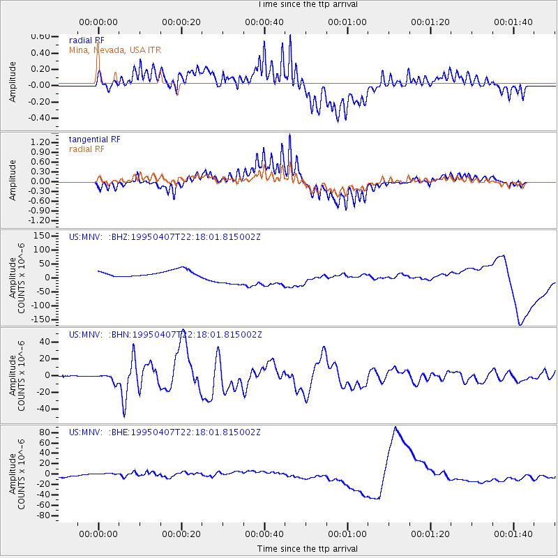
MNV Mina, Nevada, USA - Earthquake Result Viewer
*The percent match for this event was below the threshold and hence no stack was calculated.
| Earthquake location: |
Tonga Islands |
| Earthquake latitude/longitude: |
-15.2/-173.6 |
| Earthquake time(UTC): |
1995/04/07 (097) 22:06:58 GMT |
| Earthquake Depth: |
31 km |
| Earthquake Magnitude: |
6.7 MB, 8.0 MS, 7.5 UNKNOWN, 7.1 MD |
| Earthquake Catalog/Contributor: |
WHDF/NEIC |
|
| Network: |
US United States National Seismic Network |
| Station: |
MNV Mina, Nevada, USA |
| Lat/Lon: |
38.43 N/118.15 W |
| Elevation: |
1524 m |
|
| Distance: |
74.4 deg |
| Az: |
42.185 deg |
| Baz: |
235.646 deg |
| Ray Param: |
$rayparam |
*The percent match for this event was below the threshold and hence was not used in the summary stack. |
|
| Radial Match: |
68.34848 % |
| Radial Bump: |
400 |
| Transverse Match: |
87.71143 % |
| Transverse Bump: |
400 |
| SOD ConfigId: |
4480 |
| Insert Time: |
2010-03-05 06:50:42.087 +0000 |
| GWidth: |
2.5 |
| Max Bumps: |
400 |
| Tol: |
0.001 |
|
Signal To Noise
| Channel | StoN | STA | LTA |
| US:MNV: :BHN:19950407T22:18:01.815002Z | 14.218747 | 4.988536E-6 | 3.5084219E-7 |
| US:MNV: :BHE:19950407T22:18:01.815002Z | 2.4223142 | 5.6721765E-6 | 2.3416353E-6 |
| US:MNV: :BHZ:19950407T22:18:01.815002Z | 3.6176488 | 3.77975E-5 | 1.0448084E-5 |
| Arrivals |
| Ps | |
| PpPs | |
| PsPs/PpSs | |


