You are here: Home > Network List > US - United States National Seismic Network Stations List
> Station MNV Mina, Nevada, USA > Earthquake Result Viewer
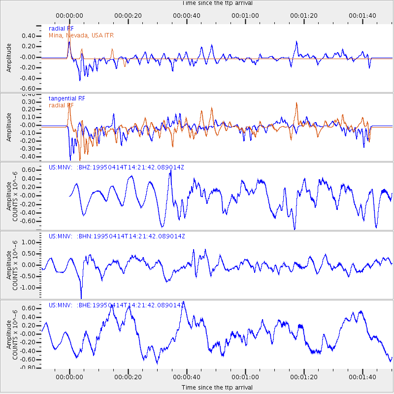
MNV Mina, Nevada, USA - Earthquake Result Viewer
*The percent match for this event was below the threshold and hence no stack was calculated.
| Earthquake location: |
Ecuador |
| Earthquake latitude/longitude: |
-1.9/-77.5 |
| Earthquake time(UTC): |
1995/04/14 (104) 14:12:59 GMT |
| Earthquake Depth: |
165 km |
| Earthquake Magnitude: |
5.5 MB, 5.4 UNKNOWN |
| Earthquake Catalog/Contributor: |
WHDF/NEIC |
|
| Network: |
US United States National Seismic Network |
| Station: |
MNV Mina, Nevada, USA |
| Lat/Lon: |
38.43 N/118.15 W |
| Elevation: |
1524 m |
|
| Distance: |
54.9 deg |
| Az: |
321.296 deg |
| Baz: |
127.273 deg |
| Ray Param: |
$rayparam |
*The percent match for this event was below the threshold and hence was not used in the summary stack. |
|
| Radial Match: |
60.78757 % |
| Radial Bump: |
374 |
| Transverse Match: |
56.68084 % |
| Transverse Bump: |
365 |
| SOD ConfigId: |
4480 |
| Insert Time: |
2010-03-05 06:50:42.757 +0000 |
| GWidth: |
2.5 |
| Max Bumps: |
400 |
| Tol: |
0.001 |
|
Signal To Noise
| Channel | StoN | STA | LTA |
| US:MNV: :BHN:19950414T14:21:42.089014Z | 2.3774998 | 5.0122753E-7 | 2.1082127E-7 |
| US:MNV: :BHE:19950414T14:21:42.089014Z | 2.6871607 | 3.7942212E-7 | 1.4119814E-7 |
| US:MNV: :BHZ:19950414T14:21:42.089014Z | 2.1833847 | 4.6440056E-7 | 2.1269756E-7 |
| Arrivals |
| Ps | |
| PpPs | |
| PsPs/PpSs | |


