You are here: Home > Network List > US - United States National Seismic Network Stations List
> Station MNV Mina, Nevada, USA > Earthquake Result Viewer
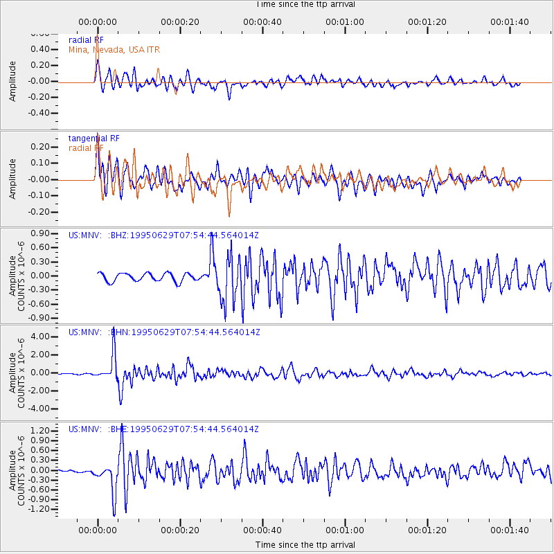
MNV Mina, Nevada, USA - Earthquake Result Viewer
*The percent match for this event was below the threshold and hence no stack was calculated.
| Earthquake location: |
Kuril Islands |
| Earthquake latitude/longitude: |
48.8/154.5 |
| Earthquake time(UTC): |
1995/06/29 (180) 07:45:09 GMT |
| Earthquake Depth: |
62 km |
| Earthquake Magnitude: |
5.9 MB, 6.0 UNKNOWN, 6.0 MW |
| Earthquake Catalog/Contributor: |
WHDF/NEIC |
|
| Network: |
US United States National Seismic Network |
| Station: |
MNV Mina, Nevada, USA |
| Lat/Lon: |
38.43 N/118.15 W |
| Elevation: |
1524 m |
|
| Distance: |
60.8 deg |
| Az: |
64.004 deg |
| Baz: |
310.804 deg |
| Ray Param: |
$rayparam |
*The percent match for this event was below the threshold and hence was not used in the summary stack. |
|
| Radial Match: |
76.55749 % |
| Radial Bump: |
400 |
| Transverse Match: |
72.691666 % |
| Transverse Bump: |
400 |
| SOD ConfigId: |
4480 |
| Insert Time: |
2010-03-05 06:50:43.374 +0000 |
| GWidth: |
2.5 |
| Max Bumps: |
400 |
| Tol: |
0.001 |
|
Signal To Noise
| Channel | StoN | STA | LTA |
| US:MNV: :BHN:19950629T07:54:44.564014Z | 22.24054 | 1.549879E-6 | 6.968712E-8 |
| US:MNV: :BHE:19950629T07:54:44.564014Z | 7.228037 | 4.7065288E-7 | 6.51149E-8 |
| US:MNV: :BHZ:19950629T07:54:44.564014Z | 5.3973756 | 4.703387E-7 | 8.714211E-8 |
| Arrivals |
| Ps | |
| PpPs | |
| PsPs/PpSs | |


