You are here: Home > Network List > 7A - Mid-Atlantic Geophysical Integrative Collaboration Stations List
> Station BARB Louisa, Virginia USA > Earthquake Result Viewer
BARB Louisa, Virginia USA - Earthquake Result Viewer
| Earthquake location: |
Northern Peru |
| Earthquake latitude/longitude: |
-5.6/-77.0 |
| Earthquake time(UTC): |
2016/09/10 (254) 10:08:20 GMT |
| Earthquake Depth: |
114 km |
| Earthquake Magnitude: |
6.0 MB |
| Earthquake Catalog/Contributor: |
NEIC PDE/NEIC ALERT |
|
| Network: |
7A Mid-Atlantic Geophysical Integrative Collaboration |
| Station: |
BARB Louisa, Virginia USA |
| Lat/Lon: |
37.99 N/78.09 W |
| Elevation: |
84 m |
|
| Distance: |
43.4 deg |
| Az: |
358.711 deg |
| Baz: |
178.376 deg |
| Ray Param: |
0.07218536 |
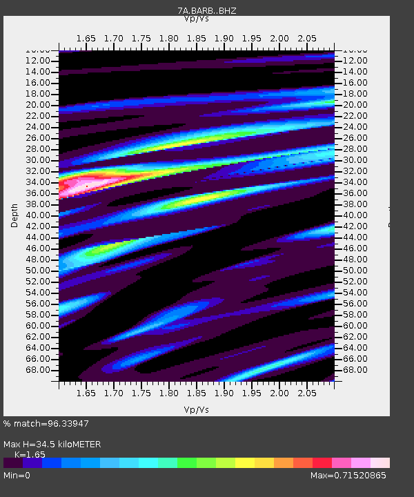
| Estimated Moho Depth: |
34.5 km |
| Estimated Crust Vp/Vs: |
1.65 |
| Assumed Crust Vp: |
6.419 km/s |
| Estimated Crust Vs: |
3.89 km/s |
| Estimated Crust Poisson's Ratio: |
0.21 |
|
| Radial Match: |
96.33947 % |
| Radial Bump: |
185 |
| Transverse Match: |
85.34567 % |
| Transverse Bump: |
400 |
| SOD ConfigId: |
11737051 |
| Insert Time: |
2019-04-25 11:52:04.216 +0000 |
| GWidth: |
2.5 |
| Max Bumps: |
400 |
| Tol: |
0.001 |
|

Signal To Noise
| Channel | StoN | STA | LTA |
| 7A:BARB: :BHZ:20160910T10:15:39.765015Z | 34.915146 | 2.9962841E-6 | 8.5816175E-8 |
| 7A:BARB: :BHN:20160910T10:15:39.765015Z | 30.815943 | 2.3188124E-6 | 7.524717E-8 |
| 7A:BARB: :BHE:20160910T10:15:39.765015Z | 7.9650216 | 6.79036E-7 | 8.525225E-8 |
| Arrivals |
| Ps | 3.7 SECOND |
| PpPs | 13 SECOND |
| PsPs/PpSs | 17 SECOND |


