You are here: Home > Network List > 7A - Mid-Atlantic Geophysical Integrative Collaboration Stations List
> Station BDEG Charles Lake, Virginia USA > Earthquake Result Viewer
BDEG Charles Lake, Virginia USA - Earthquake Result Viewer
| Earthquake location: |
Northern Peru |
| Earthquake latitude/longitude: |
-5.6/-77.0 |
| Earthquake time(UTC): |
2016/09/10 (254) 10:08:20 GMT |
| Earthquake Depth: |
114 km |
| Earthquake Magnitude: |
6.0 MB |
| Earthquake Catalog/Contributor: |
NEIC PDE/NEIC ALERT |
|
| Network: |
7A Mid-Atlantic Geophysical Integrative Collaboration |
| Station: |
BDEG Charles Lake, Virginia USA |
| Lat/Lon: |
37.33 N/77.21 W |
| Elevation: |
-21.0 m |
|
| Distance: |
42.7 deg |
| Az: |
359.714 deg |
| Baz: |
179.643 deg |
| Ray Param: |
0.07261752 |
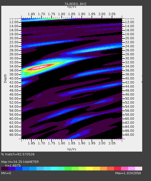
| Estimated Moho Depth: |
34.25 km |
| Estimated Crust Vp/Vs: |
1.69 |
| Assumed Crust Vp: |
6.565 km/s |
| Estimated Crust Vs: |
3.89 km/s |
| Estimated Crust Poisson's Ratio: |
0.23 |
|
| Radial Match: |
92.570526 % |
| Radial Bump: |
400 |
| Transverse Match: |
80.31968 % |
| Transverse Bump: |
400 |
| SOD ConfigId: |
11737051 |
| Insert Time: |
2019-04-25 11:52:05.257 +0000 |
| GWidth: |
2.5 |
| Max Bumps: |
400 |
| Tol: |
0.001 |
|

Signal To Noise
| Channel | StoN | STA | LTA |
| 7A:BDEG: :BHZ:20160910T10:15:34.390015Z | 37.16772 | 2.809736E-6 | 7.559614E-8 |
| 7A:BDEG: :BHN:20160910T10:15:34.390015Z | 18.84896 | 1.9977035E-6 | 1.0598481E-7 |
| 7A:BDEG: :BHE:20160910T10:15:34.390015Z | 4.217927 | 3.7085462E-7 | 8.792343E-8 |
| Arrivals |
| Ps | 3.9 SECOND |
| PpPs | 13 SECOND |
| PsPs/PpSs | 17 SECOND |


