You are here: Home > Network List > US - United States National Seismic Network Stations List
> Station MNV Mina, Nevada, USA > Earthquake Result Viewer
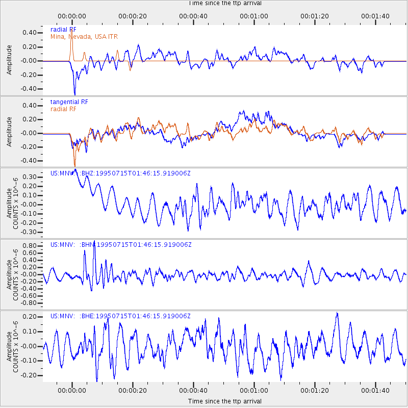
MNV Mina, Nevada, USA - Earthquake Result Viewer
*The percent match for this event was below the threshold and hence no stack was calculated.
| Earthquake location: |
Fiji Islands Region |
| Earthquake latitude/longitude: |
-19.9/-177.6 |
| Earthquake time(UTC): |
1995/07/15 (196) 01:35:14 GMT |
| Earthquake Depth: |
358 km |
| Earthquake Magnitude: |
5.7 UNKNOWN, 5.4 MB |
| Earthquake Catalog/Contributor: |
WHDF/NEIC |
|
| Network: |
US United States National Seismic Network |
| Station: |
MNV Mina, Nevada, USA |
| Lat/Lon: |
38.43 N/118.15 W |
| Elevation: |
1524 m |
|
| Distance: |
80.4 deg |
| Az: |
43.311 deg |
| Baz: |
235.297 deg |
| Ray Param: |
$rayparam |
*The percent match for this event was below the threshold and hence was not used in the summary stack. |
|
| Radial Match: |
51.099648 % |
| Radial Bump: |
400 |
| Transverse Match: |
53.25564 % |
| Transverse Bump: |
400 |
| SOD ConfigId: |
4480 |
| Insert Time: |
2010-03-05 06:50:44.053 +0000 |
| GWidth: |
2.5 |
| Max Bumps: |
400 |
| Tol: |
0.001 |
|
Signal To Noise
| Channel | StoN | STA | LTA |
| US:MNV: :BHN:19950715T01:46:15.919006Z | 1.9812925 | 2.0416739E-7 | 1.03047576E-7 |
| US:MNV: :BHE:19950715T01:46:15.919006Z | 0.75963783 | 4.6093668E-8 | 6.0678474E-8 |
| US:MNV: :BHZ:19950715T01:46:15.919006Z | 1.1521387 | 1.771928E-7 | 1.5379467E-7 |
| Arrivals |
| Ps | |
| PpPs | |
| PsPs/PpSs | |


