You are here: Home > Network List > 7A - Mid-Atlantic Geophysical Integrative Collaboration Stations List
> Station CAKE Sugar Grove, West Virginia USA > Earthquake Result Viewer
CAKE Sugar Grove, West Virginia USA - Earthquake Result Viewer
| Earthquake location: |
Northern Peru |
| Earthquake latitude/longitude: |
-5.6/-77.0 |
| Earthquake time(UTC): |
2016/09/10 (254) 10:08:20 GMT |
| Earthquake Depth: |
114 km |
| Earthquake Magnitude: |
6.0 MB |
| Earthquake Catalog/Contributor: |
NEIC PDE/NEIC ALERT |
|
| Network: |
7A Mid-Atlantic Geophysical Integrative Collaboration |
| Station: |
CAKE Sugar Grove, West Virginia USA |
| Lat/Lon: |
38.52 N/79.30 W |
| Elevation: |
640 m |
|
| Distance: |
43.9 deg |
| Az: |
357.359 deg |
| Baz: |
176.648 deg |
| Ray Param: |
0.071838774 |
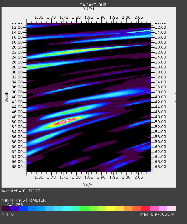
| Estimated Moho Depth: |
49.5 km |
| Estimated Crust Vp/Vs: |
1.75 |
| Assumed Crust Vp: |
6.159 km/s |
| Estimated Crust Vs: |
3.509 km/s |
| Estimated Crust Poisson's Ratio: |
0.26 |
|
| Radial Match: |
91.61172 % |
| Radial Bump: |
400 |
| Transverse Match: |
79.59386 % |
| Transverse Bump: |
400 |
| SOD ConfigId: |
11737051 |
| Insert Time: |
2019-04-25 11:52:05.399 +0000 |
| GWidth: |
2.5 |
| Max Bumps: |
400 |
| Tol: |
0.001 |
|

Signal To Noise
| Channel | StoN | STA | LTA |
| 7A:CAKE: :BHZ:20160910T10:15:44.304993Z | 28.59627 | 2.55652E-6 | 8.940047E-8 |
| 7A:CAKE: :BHN:20160910T10:15:44.304993Z | 21.790745 | 1.6300138E-6 | 7.480303E-8 |
| 7A:CAKE: :BHE:20160910T10:15:44.304993Z | 2.8988729 | 2.932814E-7 | 1.0117084E-7 |
| Arrivals |
| Ps | 6.4 SECOND |
| PpPs | 21 SECOND |
| PsPs/PpSs | 27 SECOND |


