You are here: Home > Network List > 7A - Mid-Atlantic Geophysical Integrative Collaboration Stations List
> Station LADY Linville, Virginia USA > Earthquake Result Viewer
LADY Linville, Virginia USA - Earthquake Result Viewer
| Earthquake location: |
Northern Peru |
| Earthquake latitude/longitude: |
-5.6/-77.0 |
| Earthquake time(UTC): |
2016/09/10 (254) 10:08:20 GMT |
| Earthquake Depth: |
114 km |
| Earthquake Magnitude: |
6.0 MB |
| Earthquake Catalog/Contributor: |
NEIC PDE/NEIC ALERT |
|
| Network: |
7A Mid-Atlantic Geophysical Integrative Collaboration |
| Station: |
LADY Linville, Virginia USA |
| Lat/Lon: |
38.51 N/78.76 W |
| Elevation: |
401 m |
|
| Distance: |
43.9 deg |
| Az: |
357.963 deg |
| Baz: |
177.416 deg |
| Ray Param: |
0.07185955 |
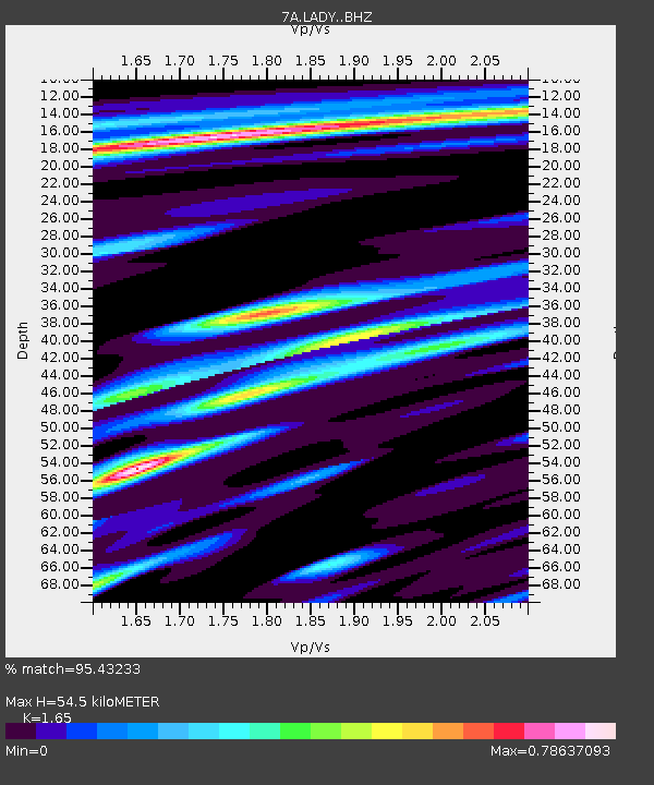
| Estimated Moho Depth: |
54.5 km |
| Estimated Crust Vp/Vs: |
1.65 |
| Assumed Crust Vp: |
6.159 km/s |
| Estimated Crust Vs: |
3.733 km/s |
| Estimated Crust Poisson's Ratio: |
0.21 |
|
| Radial Match: |
95.43233 % |
| Radial Bump: |
319 |
| Transverse Match: |
86.018105 % |
| Transverse Bump: |
400 |
| SOD ConfigId: |
11737051 |
| Insert Time: |
2019-04-25 11:52:10.768 +0000 |
| GWidth: |
2.5 |
| Max Bumps: |
400 |
| Tol: |
0.001 |
|

Signal To Noise
| Channel | StoN | STA | LTA |
| 7A:LADY: :BHZ:20160910T10:15:44.040009Z | 23.9475 | 2.62872E-6 | 1.0977012E-7 |
| 7A:LADY: :BHN:20160910T10:15:44.040009Z | 18.267897 | 1.3972499E-6 | 7.6486636E-8 |
| 7A:LADY: :BHE:20160910T10:15:44.040009Z | 2.8431284 | 1.9118177E-7 | 6.724345E-8 |
| Arrivals |
| Ps | 6.1 SECOND |
| PpPs | 22 SECOND |
| PsPs/PpSs | 28 SECOND |


