You are here: Home > Network List > US - United States National Seismic Network Stations List
> Station MNV Mina, Nevada, USA > Earthquake Result Viewer
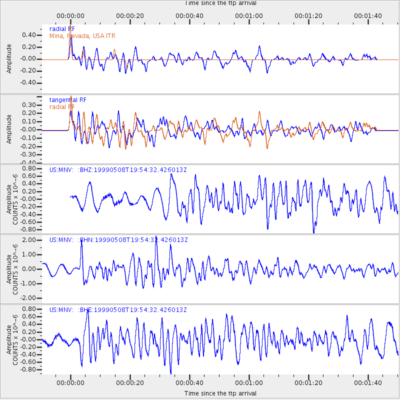
MNV Mina, Nevada, USA - Earthquake Result Viewer
*The percent match for this event was below the threshold and hence no stack was calculated.
| Earthquake location: |
Kuril Islands |
| Earthquake latitude/longitude: |
45.4/151.6 |
| Earthquake time(UTC): |
1999/05/08 (128) 19:44:35 GMT |
| Earthquake Depth: |
63 km |
| Earthquake Magnitude: |
6.2 MB, 5.3 MS, 5.9 MW, 5.9 MW |
| Earthquake Catalog/Contributor: |
WHDF/NEIC |
|
| Network: |
US United States National Seismic Network |
| Station: |
MNV Mina, Nevada, USA |
| Lat/Lon: |
38.43 N/118.15 W |
| Elevation: |
1524 m |
|
| Distance: |
64.1 deg |
| Az: |
60.859 deg |
| Baz: |
308.477 deg |
| Ray Param: |
$rayparam |
*The percent match for this event was below the threshold and hence was not used in the summary stack. |
|
| Radial Match: |
66.254814 % |
| Radial Bump: |
400 |
| Transverse Match: |
77.19586 % |
| Transverse Bump: |
400 |
| SOD ConfigId: |
4480 |
| Insert Time: |
2010-03-05 06:50:47.578 +0000 |
| GWidth: |
2.5 |
| Max Bumps: |
400 |
| Tol: |
0.001 |
|
Signal To Noise
| Channel | StoN | STA | LTA |
| US:MNV: :BHN:19990508T19:54:32.426013Z | 2.6766317 | 6.5440196E-7 | 2.4448713E-7 |
| US:MNV: :BHE:19990508T19:54:32.426013Z | 2.6760743 | 2.492202E-7 | 9.3129024E-8 |
| US:MNV: :BHZ:19990508T19:54:32.426013Z | 2.4312522 | 3.8583497E-7 | 1.5869804E-7 |
| Arrivals |
| Ps | |
| PpPs | |
| PsPs/PpSs | |


