You are here: Home > Network List > US - United States National Seismic Network Stations List
> Station MNV Mina, Nevada, USA > Earthquake Result Viewer
MNV Mina, Nevada, USA - Earthquake Result Viewer
*The percent match for this event was below the threshold and hence no stack was calculated.
| Earthquake location: |
Hokkaido, Japan Region |
| Earthquake latitude/longitude: |
43.0/143.8 |
| Earthquake time(UTC): |
1999/05/12 (132) 17:59:22 GMT |
| Earthquake Depth: |
103 km |
| Earthquake Magnitude: |
5.9 MB, 6.2 MW, 6.1 MW |
| Earthquake Catalog/Contributor: |
WHDF/NEIC |
|
| Network: |
US United States National Seismic Network |
| Station: |
MNV Mina, Nevada, USA |
| Lat/Lon: |
38.43 N/118.15 W |
| Elevation: |
1524 m |
|
| Distance: |
70.1 deg |
| Az: |
55.809 deg |
| Baz: |
309.44 deg |
| Ray Param: |
$rayparam |
*The percent match for this event was below the threshold and hence was not used in the summary stack. |
|
| Radial Match: |
78.238914 % |
| Radial Bump: |
400 |
| Transverse Match: |
76.905045 % |
| Transverse Bump: |
400 |
| SOD ConfigId: |
4480 |
| Insert Time: |
2010-03-05 06:50:48.423 +0000 |
| GWidth: |
2.5 |
| Max Bumps: |
400 |
| Tol: |
0.001 |
|
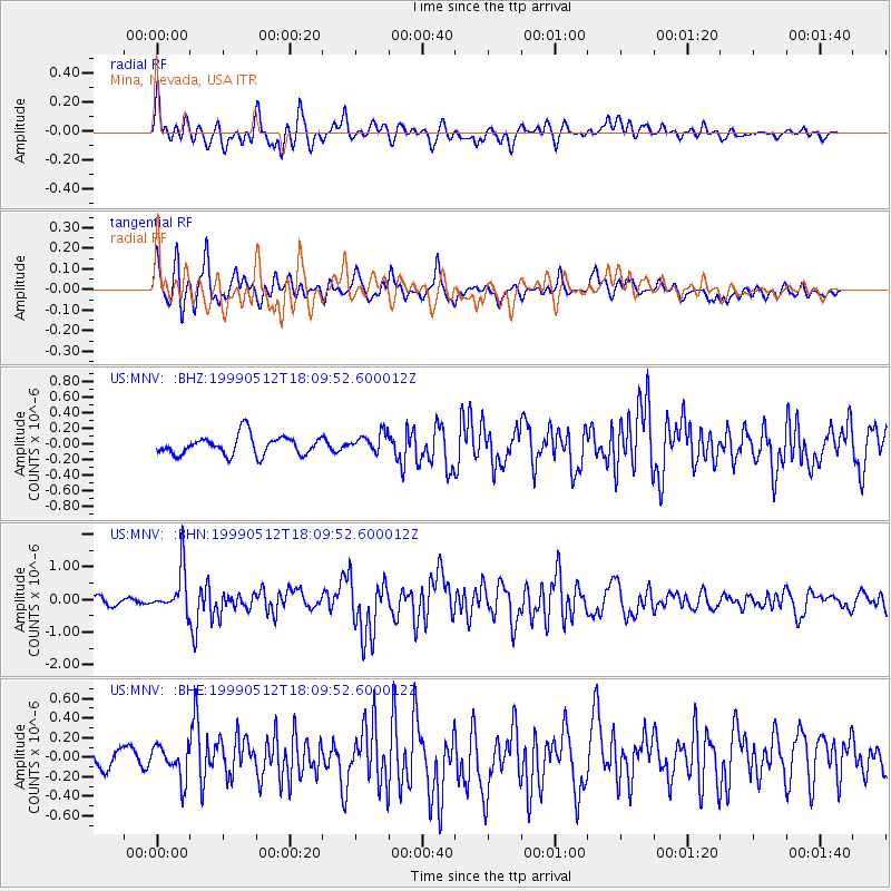
Signal To Noise
| Channel | StoN | STA | LTA |
| US:MNV: :BHN:19990512T18:09:52.600012Z | 7.5989094 | 6.64251E-7 | 8.741399E-8 |
| US:MNV: :BHE:19990512T18:09:52.600012Z | 1.8021699 | 1.7044255E-7 | 9.457629E-8 |
| US:MNV: :BHZ:19990512T18:09:52.600012Z | 1.0093236 | 1.2284191E-7 | 1.2170716E-7 |
| Arrivals |
| Ps | |
| PpPs | |
| PsPs/PpSs | |


