You are here: Home > Network List > AG - Arkansas Seismic Network Stations List
> Station U40A Yellville, AR > Earthquake Result Viewer
U40A Yellville, AR - Earthquake Result Viewer
| Earthquake location: |
Northern Peru |
| Earthquake latitude/longitude: |
-5.6/-77.0 |
| Earthquake time(UTC): |
2016/09/10 (254) 10:08:20 GMT |
| Earthquake Depth: |
114 km |
| Earthquake Magnitude: |
6.0 MB |
| Earthquake Catalog/Contributor: |
NEIC PDE/NEIC ALERT |
|
| Network: |
AG Arkansas Seismic Network |
| Station: |
U40A Yellville, AR |
| Lat/Lon: |
36.36 N/92.85 W |
| Elevation: |
374 m |
|
| Distance: |
44.3 deg |
| Az: |
341.552 deg |
| Baz: |
157.035 deg |
| Ray Param: |
0.071614474 |
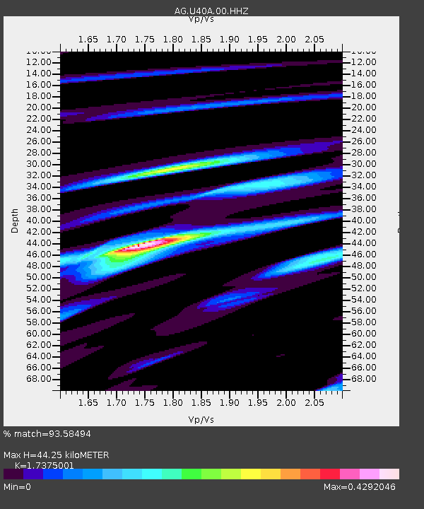
| Estimated Moho Depth: |
44.25 km |
| Estimated Crust Vp/Vs: |
1.74 |
| Assumed Crust Vp: |
6.53 km/s |
| Estimated Crust Vs: |
3.759 km/s |
| Estimated Crust Poisson's Ratio: |
0.25 |
|
| Radial Match: |
93.58494 % |
| Radial Bump: |
272 |
| Transverse Match: |
78.08337 % |
| Transverse Bump: |
383 |
| SOD ConfigId: |
11737051 |
| Insert Time: |
2019-04-25 11:52:33.123 +0000 |
| GWidth: |
2.5 |
| Max Bumps: |
400 |
| Tol: |
0.001 |
|
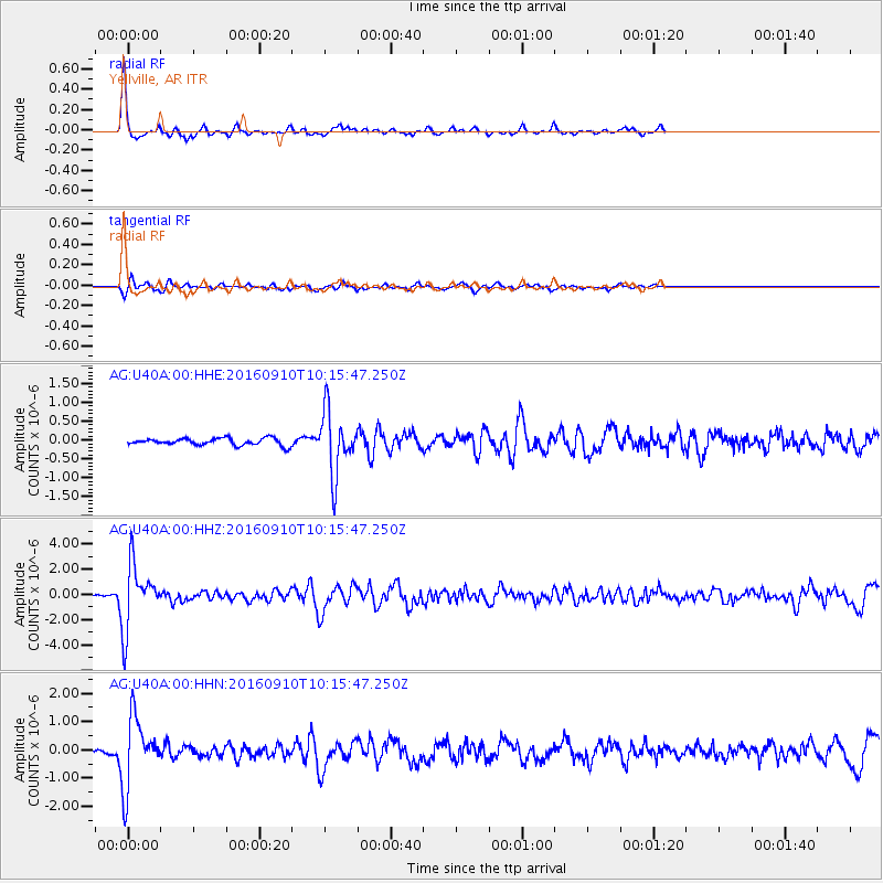
Signal To Noise
| Channel | StoN | STA | LTA |
| AG:U40A:00:HHZ:20160910T10:15:47.250Z | 21.364462 | 2.5533518E-6 | 1.1951397E-7 |
| AG:U40A:00:HHN:20160910T10:15:47.250Z | 18.938177 | 1.2278596E-6 | 6.483515E-8 |
| AG:U40A:00:HHE:20160910T10:15:47.250Z | 8.879568 | 8.374619E-7 | 9.431336E-8 |
| Arrivals |
| Ps | 5.3 SECOND |
| PpPs | 17 SECOND |
| PsPs/PpSs | 23 SECOND |


