You are here: Home > Network List > CI - Caltech Regional Seismic Network Stations List
> Station PLM Palomar, California, USA > Earthquake Result Viewer
PLM Palomar, California, USA - Earthquake Result Viewer
| Earthquake location: |
Volcano Islands, Japan Region |
| Earthquake latitude/longitude: |
22.3/143.7 |
| Earthquake time(UTC): |
2000/03/28 (088) 11:00:22 GMT |
| Earthquake Depth: |
126 km |
| Earthquake Magnitude: |
6.8 MB, 7.6 MS, 7.6 MW, 7.6 MW |
| Earthquake Catalog/Contributor: |
WHDF/NEIC |
|
| Network: |
CI Caltech Regional Seismic Network |
| Station: |
PLM Palomar, California, USA |
| Lat/Lon: |
33.35 N/116.86 W |
| Elevation: |
1660 m |
|
| Distance: |
85.4 deg |
| Az: |
55.934 deg |
| Baz: |
293.602 deg |
| Ray Param: |
0.044509303 |
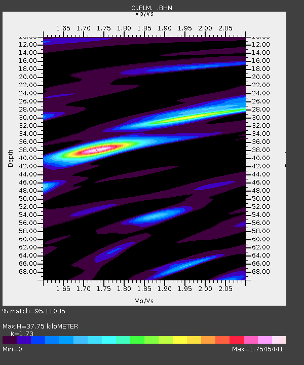
| Estimated Moho Depth: |
37.75 km |
| Estimated Crust Vp/Vs: |
1.73 |
| Assumed Crust Vp: |
6.264 km/s |
| Estimated Crust Vs: |
3.621 km/s |
| Estimated Crust Poisson's Ratio: |
0.25 |
|
| Radial Match: |
95.11085 % |
| Radial Bump: |
400 |
| Transverse Match: |
85.99935 % |
| Transverse Bump: |
400 |
| SOD ConfigId: |
3744 |
| Insert Time: |
2010-02-26 00:43:31.422 +0000 |
| GWidth: |
2.5 |
| Max Bumps: |
400 |
| Tol: |
0.001 |
|

Signal To Noise
| Channel | StoN | STA | LTA |
| CI:PLM: :BHN:20000328T11:12:14.619009Z | 0.6891313 | 2.2394387E-7 | 3.2496544E-7 |
| CI:PLM: :BHE:20000328T11:12:14.619009Z | 1.0002086 | 3.3448254E-7 | 3.344128E-7 |
| CI:PLM: :BHZ:20000328T11:12:14.619009Z | 2.1336248 | 9.446365E-7 | 4.4273787E-7 |
| Arrivals |
| Ps | 4.5 SECOND |
| PpPs | 16 SECOND |
| PsPs/PpSs | 21 SECOND |


