You are here: Home > Network List > CI - Caltech Regional Seismic Network Stations List
> Station MPP McPhearson Peak > Earthquake Result Viewer
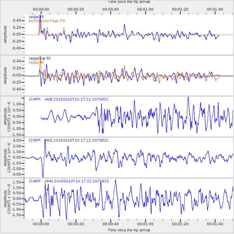
MPP McPhearson Peak - Earthquake Result Viewer
*The percent match for this event was below the threshold and hence no stack was calculated.
| Earthquake location: |
Northern Peru |
| Earthquake latitude/longitude: |
-5.6/-77.0 |
| Earthquake time(UTC): |
2016/09/10 (254) 10:08:20 GMT |
| Earthquake Depth: |
114 km |
| Earthquake Magnitude: |
6.0 MB |
| Earthquake Catalog/Contributor: |
NEIC PDE/NEIC ALERT |
|
| Network: |
CI Caltech Regional Seismic Network |
| Station: |
MPP McPhearson Peak |
| Lat/Lon: |
34.89 N/119.81 W |
| Elevation: |
1739 m |
|
| Distance: |
57.0 deg |
| Az: |
318.186 deg |
| Baz: |
126.175 deg |
| Ray Param: |
$rayparam |
*The percent match for this event was below the threshold and hence was not used in the summary stack. |
|
| Radial Match: |
77.83293 % |
| Radial Bump: |
400 |
| Transverse Match: |
66.64642 % |
| Transverse Bump: |
400 |
| SOD ConfigId: |
11737051 |
| Insert Time: |
2019-04-25 11:55:23.562 +0000 |
| GWidth: |
2.5 |
| Max Bumps: |
400 |
| Tol: |
0.001 |
|
Signal To Noise
| Channel | StoN | STA | LTA |
| CI:MPP: :HHZ:20160910T10:17:22.307983Z | 9.456544 | 1.5174713E-6 | 1.6046786E-7 |
| CI:MPP: :HHN:20160910T10:17:22.307983Z | 4.0838118 | 8.0505237E-7 | 1.9713258E-7 |
| CI:MPP: :HHE:20160910T10:17:22.307983Z | 2.6852765 | 6.3163935E-7 | 2.3522321E-7 |
| Arrivals |
| Ps | |
| PpPs | |
| PsPs/PpSs | |


