You are here: Home > Network List > LD - Lamont-Doherty Cooperative Seismographic Network Stations List
> Station LUPA Lehigh University, PA > Earthquake Result Viewer
LUPA Lehigh University, PA - Earthquake Result Viewer
| Earthquake location: |
Northern Peru |
| Earthquake latitude/longitude: |
-5.6/-77.0 |
| Earthquake time(UTC): |
2016/09/10 (254) 10:08:20 GMT |
| Earthquake Depth: |
114 km |
| Earthquake Magnitude: |
6.0 MB |
| Earthquake Catalog/Contributor: |
NEIC PDE/NEIC ALERT |
|
| Network: |
LD Lamont-Doherty Cooperative Seismographic Network |
| Station: |
LUPA Lehigh University, PA |
| Lat/Lon: |
40.60 N/75.37 W |
| Elevation: |
236 m |
|
| Distance: |
46.0 deg |
| Az: |
1.687 deg |
| Baz: |
182.206 deg |
| Ray Param: |
0.07054684 |
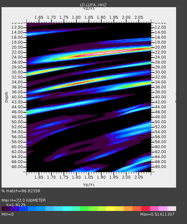
| Estimated Moho Depth: |
22.0 km |
| Estimated Crust Vp/Vs: |
1.91 |
| Assumed Crust Vp: |
6.283 km/s |
| Estimated Crust Vs: |
3.285 km/s |
| Estimated Crust Poisson's Ratio: |
0.31 |
|
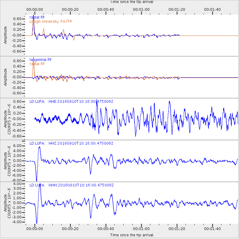
| Radial Match: |
96.92359 % |
| Radial Bump: |
279 |
| Transverse Match: |
72.795204 % |
| Transverse Bump: |
400 |
| SOD ConfigId: |
11737051 |
| Insert Time: |
2019-04-25 11:58:13.398 +0000 |
| GWidth: |
2.5 |
| Max Bumps: |
400 |
| Tol: |
0.001 |
|
Signal To Noise
| Channel | StoN | STA | LTA |
| LD:LUPA: :HHZ:20160910T10:16:00.475006Z | 32.706223 | 3.6962717E-6 | 1.1301432E-7 |
| LD:LUPA: :HHN:20160910T10:16:00.475006Z | 20.172806 | 2.1978626E-6 | 1.0895175E-7 |
| LD:LUPA: :HHE:20160910T10:16:00.475006Z | 2.9667597 | 2.568875E-7 | 8.658857E-8 |
| Arrivals |
| Ps | 3.4 SECOND |
| PpPs | 9.7 SECOND |
| PsPs/PpSs | 13 SECOND |


