You are here: Home > Network List > LD - Lamont-Doherty Cooperative Seismographic Network Stations List
> Station MVL Millersville University, PA > Earthquake Result Viewer
MVL Millersville University, PA - Earthquake Result Viewer
| Earthquake location: |
Northern Peru |
| Earthquake latitude/longitude: |
-5.6/-77.0 |
| Earthquake time(UTC): |
2016/09/10 (254) 10:08:20 GMT |
| Earthquake Depth: |
114 km |
| Earthquake Magnitude: |
6.0 MB |
| Earthquake Catalog/Contributor: |
NEIC PDE/NEIC ALERT |
|
| Network: |
LD Lamont-Doherty Cooperative Seismographic Network |
| Station: |
MVL Millersville University, PA |
| Lat/Lon: |
40.00 N/76.35 W |
| Elevation: |
91 m |
|
| Distance: |
45.4 deg |
| Az: |
0.663 deg |
| Baz: |
180.859 deg |
| Ray Param: |
0.0709271 |
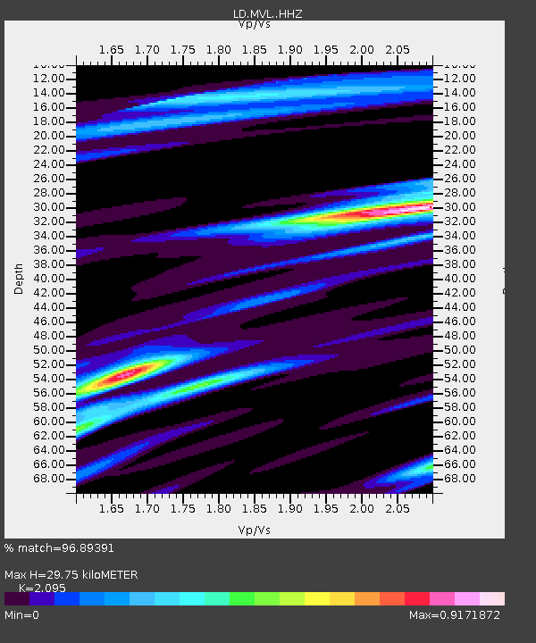
| Estimated Moho Depth: |
29.75 km |
| Estimated Crust Vp/Vs: |
2.10 |
| Assumed Crust Vp: |
6.419 km/s |
| Estimated Crust Vs: |
3.064 km/s |
| Estimated Crust Poisson's Ratio: |
0.35 |
|
| Radial Match: |
96.89391 % |
| Radial Bump: |
234 |
| Transverse Match: |
87.5486 % |
| Transverse Bump: |
329 |
| SOD ConfigId: |
11737051 |
| Insert Time: |
2019-04-25 11:58:16.078 +0000 |
| GWidth: |
2.5 |
| Max Bumps: |
400 |
| Tol: |
0.001 |
|

Signal To Noise
| Channel | StoN | STA | LTA |
| LD:MVL: :HHZ:20160910T10:15:55.619995Z | 44.394062 | 3.6462225E-6 | 8.213311E-8 |
| LD:MVL: :HHN:20160910T10:15:55.619995Z | 26.010166 | 2.4298258E-6 | 9.3418315E-8 |
| LD:MVL: :HHE:20160910T10:15:55.619995Z | 9.413303 | 7.6748375E-7 | 8.153182E-8 |
| Arrivals |
| Ps | 5.4 SECOND |
| PpPs | 14 SECOND |
| PsPs/PpSs | 19 SECOND |


