You are here: Home > Network List > LD - Lamont-Doherty Cooperative Seismographic Network Stations List
> Station WUPA West Chester University of Pennsylvania > Earthquake Result Viewer
WUPA West Chester University of Pennsylvania - Earthquake Result Viewer
| Earthquake location: |
Northern Peru |
| Earthquake latitude/longitude: |
-5.6/-77.0 |
| Earthquake time(UTC): |
2016/09/10 (254) 10:08:20 GMT |
| Earthquake Depth: |
114 km |
| Earthquake Magnitude: |
6.0 MB |
| Earthquake Catalog/Contributor: |
NEIC PDE/NEIC ALERT |
|
| Network: |
LD Lamont-Doherty Cooperative Seismographic Network |
| Station: |
WUPA West Chester University of Pennsylvania |
| Lat/Lon: |
39.93 N/75.61 W |
| Elevation: |
86 m |
|
| Distance: |
45.3 deg |
| Az: |
1.47 deg |
| Baz: |
181.903 deg |
| Ray Param: |
0.07095961 |
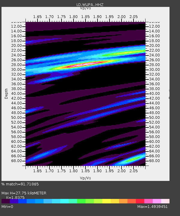
| Estimated Moho Depth: |
27.75 km |
| Estimated Crust Vp/Vs: |
1.84 |
| Assumed Crust Vp: |
6.287 km/s |
| Estimated Crust Vs: |
3.422 km/s |
| Estimated Crust Poisson's Ratio: |
0.29 |
|
| Radial Match: |
91.71865 % |
| Radial Bump: |
204 |
| Transverse Match: |
74.01691 % |
| Transverse Bump: |
400 |
| SOD ConfigId: |
11737051 |
| Insert Time: |
2019-04-25 11:58:24.714 +0000 |
| GWidth: |
2.5 |
| Max Bumps: |
400 |
| Tol: |
0.001 |
|
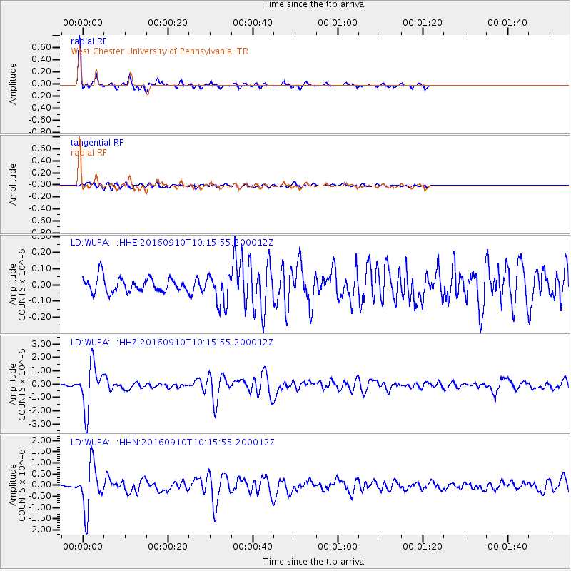
Signal To Noise
| Channel | StoN | STA | LTA |
| LD:WUPA: :HHZ:20160910T10:15:55.200012Z | 45.784992 | 1.6908855E-6 | 3.6931E-8 |
| LD:WUPA: :HHN:20160910T10:15:55.200012Z | 21.291119 | 1.0453648E-6 | 4.909863E-8 |
| LD:WUPA: :HHE:20160910T10:15:55.200012Z | 2.2746701 | 1.0292892E-7 | 4.525004E-8 |
| Arrivals |
| Ps | 3.9 SECOND |
| PpPs | 12 SECOND |
| PsPs/PpSs | 16 SECOND |


