You are here: Home > Network List > N4 - Central and EAstern US Network Stations List
> Station 146B Union, MS, USA > Earthquake Result Viewer
146B Union, MS, USA - Earthquake Result Viewer
| Earthquake location: |
Northern Peru |
| Earthquake latitude/longitude: |
-5.6/-77.0 |
| Earthquake time(UTC): |
2016/09/10 (254) 10:08:20 GMT |
| Earthquake Depth: |
114 km |
| Earthquake Magnitude: |
6.0 MB |
| Earthquake Catalog/Contributor: |
NEIC PDE/NEIC ALERT |
|
| Network: |
N4 Central and EAstern US Network |
| Station: |
146B Union, MS, USA |
| Lat/Lon: |
32.64 N/89.06 W |
| Elevation: |
161 m |
|
| Distance: |
39.7 deg |
| Az: |
343.939 deg |
| Baz: |
160.952 deg |
| Ray Param: |
0.07443459 |
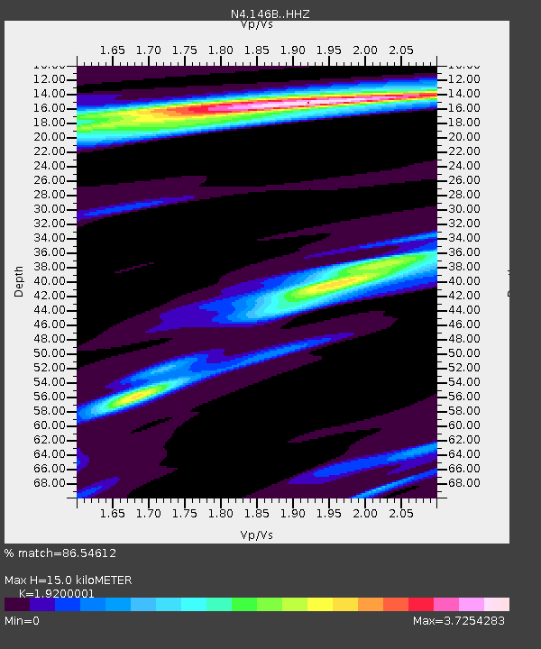
| Estimated Moho Depth: |
15.0 km |
| Estimated Crust Vp/Vs: |
1.92 |
| Assumed Crust Vp: |
6.201 km/s |
| Estimated Crust Vs: |
3.23 km/s |
| Estimated Crust Poisson's Ratio: |
0.31 |
|
| Radial Match: |
86.54612 % |
| Radial Bump: |
296 |
| Transverse Match: |
68.34859 % |
| Transverse Bump: |
397 |
| SOD ConfigId: |
11737051 |
| Insert Time: |
2019-04-25 11:58:39.483 +0000 |
| GWidth: |
2.5 |
| Max Bumps: |
400 |
| Tol: |
0.001 |
|

Signal To Noise
| Channel | StoN | STA | LTA |
| N4:146B: :HHZ:20160910T10:15:10.070007Z | 21.83168 | 3.643146E-6 | 1.6687429E-7 |
| N4:146B: :HHN:20160910T10:15:10.070007Z | 6.664533 | 1.8657541E-6 | 2.7995273E-7 |
| N4:146B: :HHE:20160910T10:15:10.070007Z | 4.6506352 | 1.1652389E-6 | 2.5055476E-7 |
| Arrivals |
| Ps | 2.4 SECOND |
| PpPs | 6.7 SECOND |
| PsPs/PpSs | 9.0 SECOND |


