You are here: Home > Network List > N4 - Central and EAstern US Network Stations List
> Station L64A Middleborough, MA, USA > Earthquake Result Viewer
L64A Middleborough, MA, USA - Earthquake Result Viewer
| Earthquake location: |
Northern Peru |
| Earthquake latitude/longitude: |
-5.6/-77.0 |
| Earthquake time(UTC): |
2016/09/10 (254) 10:08:20 GMT |
| Earthquake Depth: |
114 km |
| Earthquake Magnitude: |
6.0 MB |
| Earthquake Catalog/Contributor: |
NEIC PDE/NEIC ALERT |
|
| Network: |
N4 Central and EAstern US Network |
| Station: |
L64A Middleborough, MA, USA |
| Lat/Lon: |
41.94 N/70.84 W |
| Elevation: |
17 m |
|
| Distance: |
47.6 deg |
| Az: |
6.188 deg |
| Baz: |
188.267 deg |
| Ray Param: |
0.06949642 |
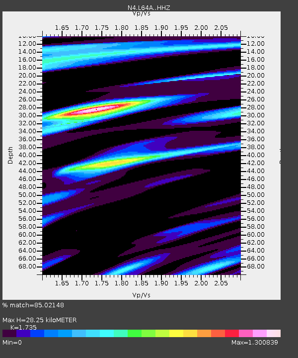
| Estimated Moho Depth: |
28.25 km |
| Estimated Crust Vp/Vs: |
1.74 |
| Assumed Crust Vp: |
6.472 km/s |
| Estimated Crust Vs: |
3.73 km/s |
| Estimated Crust Poisson's Ratio: |
0.25 |
|
| Radial Match: |
85.02148 % |
| Radial Bump: |
339 |
| Transverse Match: |
57.2049 % |
| Transverse Bump: |
400 |
| SOD ConfigId: |
11737051 |
| Insert Time: |
2019-04-25 11:59:25.676 +0000 |
| GWidth: |
2.5 |
| Max Bumps: |
400 |
| Tol: |
0.001 |
|

Signal To Noise
| Channel | StoN | STA | LTA |
| N4:L64A: :HHZ:20160910T10:16:13.220001Z | 9.163968 | 2.141436E-6 | 2.3367998E-7 |
| N4:L64A: :HHN:20160910T10:16:13.220001Z | 7.871919 | 1.1231139E-6 | 1.4267346E-7 |
| N4:L64A: :HHE:20160910T10:16:13.220001Z | 0.67467326 | 1.2182143E-7 | 1.805636E-7 |
| Arrivals |
| Ps | 3.4 SECOND |
| PpPs | 11 SECOND |
| PsPs/PpSs | 15 SECOND |


