You are here: Home > Network List > N4 - Central and EAstern US Network Stations List
> Station O44A Mansfield, IL, USA > Earthquake Result Viewer
O44A Mansfield, IL, USA - Earthquake Result Viewer
| Earthquake location: |
Northern Peru |
| Earthquake latitude/longitude: |
-5.6/-77.0 |
| Earthquake time(UTC): |
2016/09/10 (254) 10:08:20 GMT |
| Earthquake Depth: |
114 km |
| Earthquake Magnitude: |
6.0 MB |
| Earthquake Catalog/Contributor: |
NEIC PDE/NEIC ALERT |
|
| Network: |
N4 Central and EAstern US Network |
| Station: |
O44A Mansfield, IL, USA |
| Lat/Lon: |
40.15 N/88.47 W |
| Elevation: |
213 m |
|
| Distance: |
46.7 deg |
| Az: |
347.883 deg |
| Baz: |
164.181 deg |
| Ray Param: |
0.07005633 |
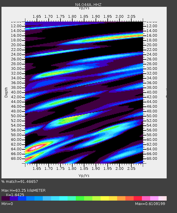
| Estimated Moho Depth: |
63.25 km |
| Estimated Crust Vp/Vs: |
1.64 |
| Assumed Crust Vp: |
6.498 km/s |
| Estimated Crust Vs: |
3.956 km/s |
| Estimated Crust Poisson's Ratio: |
0.21 |
|
| Radial Match: |
91.46657 % |
| Radial Bump: |
400 |
| Transverse Match: |
73.09636 % |
| Transverse Bump: |
400 |
| SOD ConfigId: |
11737051 |
| Insert Time: |
2019-04-25 11:59:39.382 +0000 |
| GWidth: |
2.5 |
| Max Bumps: |
400 |
| Tol: |
0.001 |
|

Signal To Noise
| Channel | StoN | STA | LTA |
| N4:O44A: :HHZ:20160910T10:16:06.339996Z | 17.46313 | 2.0859172E-6 | 1.1944691E-7 |
| N4:O44A: :HHN:20160910T10:16:06.339996Z | 10.870349 | 1.1546181E-6 | 1.0621721E-7 |
| N4:O44A: :HHE:20160910T10:16:06.339996Z | 3.7682788 | 4.5934493E-7 | 1.2189781E-7 |
| Arrivals |
| Ps | 6.7 SECOND |
| PpPs | 24 SECOND |
| PsPs/PpSs | 31 SECOND |


