You are here: Home > Network List > N4 - Central and EAstern US Network Stations List
> Station P61A Hammonton, NJ, USA > Earthquake Result Viewer
P61A Hammonton, NJ, USA - Earthquake Result Viewer
| Earthquake location: |
Northern Peru |
| Earthquake latitude/longitude: |
-5.6/-77.0 |
| Earthquake time(UTC): |
2016/09/10 (254) 10:08:20 GMT |
| Earthquake Depth: |
114 km |
| Earthquake Magnitude: |
6.0 MB |
| Earthquake Catalog/Contributor: |
NEIC PDE/NEIC ALERT |
|
| Network: |
N4 Central and EAstern US Network |
| Station: |
P61A Hammonton, NJ, USA |
| Lat/Lon: |
39.67 N/74.79 W |
| Elevation: |
22 m |
|
| Distance: |
45.1 deg |
| Az: |
2.369 deg |
| Baz: |
183.055 deg |
| Ray Param: |
0.07110545 |
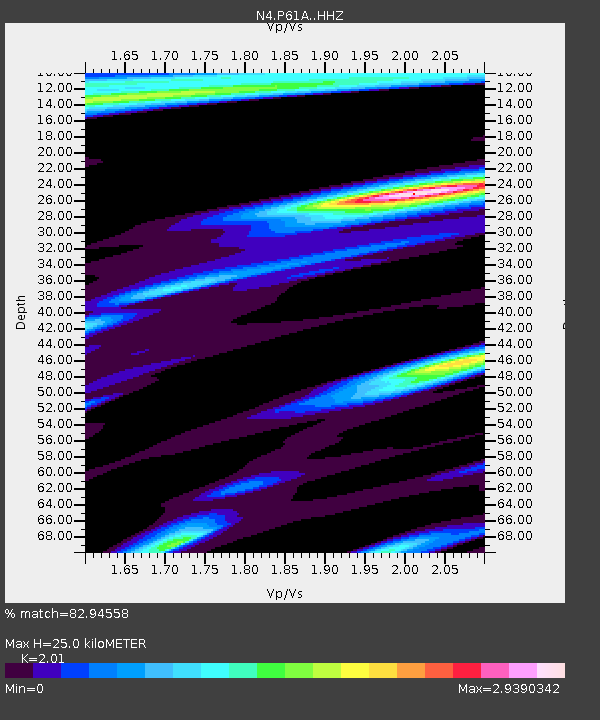
| Estimated Moho Depth: |
25.0 km |
| Estimated Crust Vp/Vs: |
2.01 |
| Assumed Crust Vp: |
6.287 km/s |
| Estimated Crust Vs: |
3.128 km/s |
| Estimated Crust Poisson's Ratio: |
0.34 |
|
| Radial Match: |
82.94558 % |
| Radial Bump: |
253 |
| Transverse Match: |
60.377563 % |
| Transverse Bump: |
305 |
| SOD ConfigId: |
11737051 |
| Insert Time: |
2019-04-25 11:59:47.136 +0000 |
| GWidth: |
2.5 |
| Max Bumps: |
400 |
| Tol: |
0.001 |
|
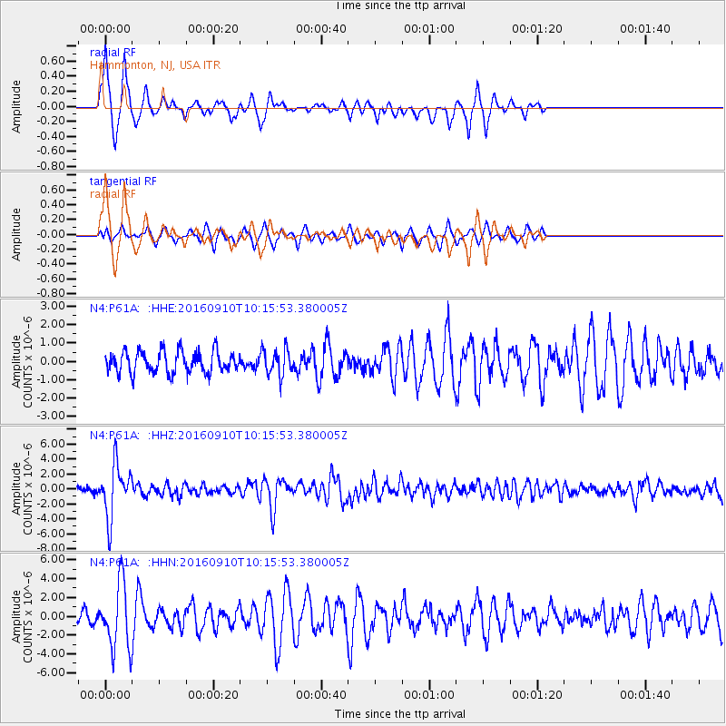
Signal To Noise
| Channel | StoN | STA | LTA |
| N4:P61A: :HHZ:20160910T10:15:53.380005Z | 8.797096 | 3.5403486E-6 | 4.0244512E-7 |
| N4:P61A: :HHN:20160910T10:15:53.380005Z | 4.6357794 | 3.5185346E-6 | 7.5899527E-7 |
| N4:P61A: :HHE:20160910T10:15:53.380005Z | 1.1500449 | 6.683872E-7 | 5.8118354E-7 |
| Arrivals |
| Ps | 4.2 SECOND |
| PpPs | 11 SECOND |
| PsPs/PpSs | 16 SECOND |


