You are here: Home > Network List > N4 - Central and EAstern US Network Stations List
> Station R49A Shelbyville, KY, USA > Earthquake Result Viewer
R49A Shelbyville, KY, USA - Earthquake Result Viewer
| Earthquake location: |
Northern Peru |
| Earthquake latitude/longitude: |
-5.6/-77.0 |
| Earthquake time(UTC): |
2016/09/10 (254) 10:08:20 GMT |
| Earthquake Depth: |
114 km |
| Earthquake Magnitude: |
6.0 MB |
| Earthquake Catalog/Contributor: |
NEIC PDE/NEIC ALERT |
|
| Network: |
N4 Central and EAstern US Network |
| Station: |
R49A Shelbyville, KY, USA |
| Lat/Lon: |
38.29 N/85.17 W |
| Elevation: |
251 m |
|
| Distance: |
44.3 deg |
| Az: |
350.747 deg |
| Baz: |
168.265 deg |
| Ray Param: |
0.07160473 |
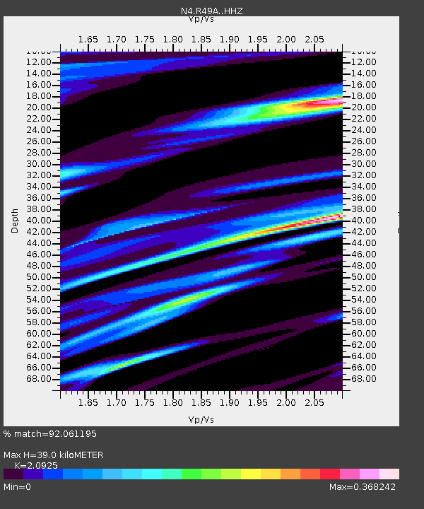
| Estimated Moho Depth: |
39.0 km |
| Estimated Crust Vp/Vs: |
2.09 |
| Assumed Crust Vp: |
6.498 km/s |
| Estimated Crust Vs: |
3.105 km/s |
| Estimated Crust Poisson's Ratio: |
0.35 |
|
| Radial Match: |
92.061195 % |
| Radial Bump: |
279 |
| Transverse Match: |
68.978195 % |
| Transverse Bump: |
374 |
| SOD ConfigId: |
11737051 |
| Insert Time: |
2019-04-25 11:59:53.265 +0000 |
| GWidth: |
2.5 |
| Max Bumps: |
400 |
| Tol: |
0.001 |
|

Signal To Noise
| Channel | StoN | STA | LTA |
| N4:R49A: :HHZ:20160910T10:15:47.359985Z | 14.990018 | 1.2924111E-6 | 8.6218115E-8 |
| N4:R49A: :HHN:20160910T10:15:47.359985Z | 11.116968 | 7.805362E-7 | 7.021124E-8 |
| N4:R49A: :HHE:20160910T10:15:47.359985Z | 2.27633 | 1.8097877E-7 | 7.950463E-8 |
| Arrivals |
| Ps | 6.9 SECOND |
| PpPs | 18 SECOND |
| PsPs/PpSs | 24 SECOND |


