You are here: Home > Network List > N4 - Central and EAstern US Network Stations List
> Station R61A Willards, MD, USA > Earthquake Result Viewer
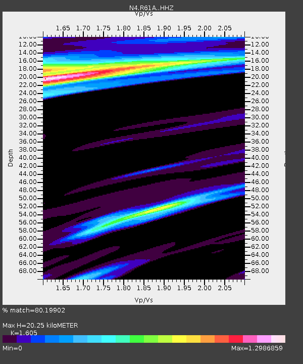
R61A Willards, MD, USA - Earthquake Result Viewer
| Earthquake location: |
Northern Peru |
| Earthquake latitude/longitude: |
-5.6/-77.0 |
| Earthquake time(UTC): |
2016/09/10 (254) 10:08:20 GMT |
| Earthquake Depth: |
114 km |
| Earthquake Magnitude: |
6.0 MB |
| Earthquake Catalog/Contributor: |
NEIC PDE/NEIC ALERT |
|
| Network: |
N4 Central and EAstern US Network |
| Station: |
R61A Willards, MD, USA |
| Lat/Lon: |
38.33 N/75.34 W |
| Elevation: |
76 m |
|
| Distance: |
43.7 deg |
| Az: |
1.85 deg |
| Baz: |
182.342 deg |
| Ray Param: |
0.0719701 |
| Estimated Moho Depth: |
20.25 km |
| Estimated Crust Vp/Vs: |
1.61 |
| Assumed Crust Vp: |
6.287 km/s |
| Estimated Crust Vs: |
3.917 km/s |
| Estimated Crust Poisson's Ratio: |
0.18 |
|
| Radial Match: |
80.19902 % |
| Radial Bump: |
331 |
| Transverse Match: |
60.042683 % |
| Transverse Bump: |
400 |
| SOD ConfigId: |
11737051 |
| Insert Time: |
2019-04-25 11:59:57.853 +0000 |
| GWidth: |
2.5 |
| Max Bumps: |
400 |
| Tol: |
0.001 |
|

Signal To Noise
| Channel | StoN | STA | LTA |
| N4:R61A: :HHZ:20160910T10:15:42.579987Z | 5.198417 | 6.909307E-6 | 1.3291174E-6 |
| N4:R61A: :HHN:20160910T10:15:42.579987Z | 4.4285707 | 3.2882738E-6 | 7.425136E-7 |
| N4:R61A: :HHE:20160910T10:15:42.579987Z | 1.2737678 | 1.3513101E-6 | 1.0608762E-6 |
| Arrivals |
| Ps | 2.1 SECOND |
| PpPs | 7.8 SECOND |
| PsPs/PpSs | 9.9 SECOND |


