You are here: Home > Network List > N4 - Central and EAstern US Network Stations List
> Station T47A Sharon Grove, KY, USA > Earthquake Result Viewer
T47A Sharon Grove, KY, USA - Earthquake Result Viewer
| Earthquake location: |
Northern Peru |
| Earthquake latitude/longitude: |
-5.6/-77.0 |
| Earthquake time(UTC): |
2016/09/10 (254) 10:08:20 GMT |
| Earthquake Depth: |
114 km |
| Earthquake Magnitude: |
6.0 MB |
| Earthquake Catalog/Contributor: |
NEIC PDE/NEIC ALERT |
|
| Network: |
N4 Central and EAstern US Network |
| Station: |
T47A Sharon Grove, KY, USA |
| Lat/Lon: |
36.99 N/87.11 W |
| Elevation: |
217 m |
|
| Distance: |
43.4 deg |
| Az: |
348.159 deg |
| Baz: |
165.223 deg |
| Ray Param: |
0.07216403 |
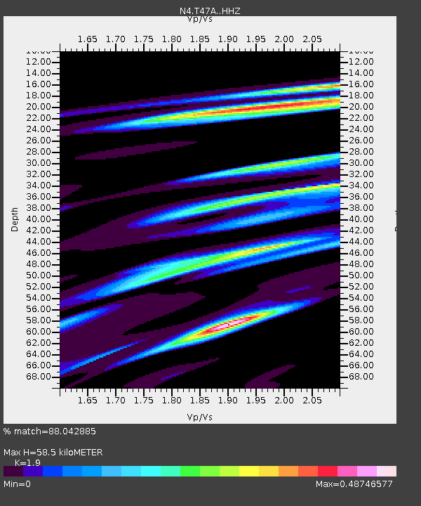
| Estimated Moho Depth: |
58.5 km |
| Estimated Crust Vp/Vs: |
1.90 |
| Assumed Crust Vp: |
6.444 km/s |
| Estimated Crust Vs: |
3.392 km/s |
| Estimated Crust Poisson's Ratio: |
0.31 |
|
| Radial Match: |
88.042885 % |
| Radial Bump: |
201 |
| Transverse Match: |
64.290405 % |
| Transverse Bump: |
400 |
| SOD ConfigId: |
11737051 |
| Insert Time: |
2019-04-25 12:00:03.275 +0000 |
| GWidth: |
2.5 |
| Max Bumps: |
400 |
| Tol: |
0.001 |
|

Signal To Noise
| Channel | StoN | STA | LTA |
| N4:T47A: :HHZ:20160910T10:15:40.070007Z | 13.388373 | 1.084753E-6 | 8.1022016E-8 |
| N4:T47A: :HHN:20160910T10:15:40.070007Z | 11.74693 | 6.3989194E-7 | 5.447312E-8 |
| N4:T47A: :HHE:20160910T10:15:40.070007Z | 4.791103 | 3.179866E-7 | 6.637023E-8 |
| Arrivals |
| Ps | 8.7 SECOND |
| PpPs | 25 SECOND |
| PsPs/PpSs | 33 SECOND |


