You are here: Home > Network List > N4 - Central and EAstern US Network Stations List
> Station V52A Sevierville, TN, USA > Earthquake Result Viewer
V52A Sevierville, TN, USA - Earthquake Result Viewer
| Earthquake location: |
Northern Peru |
| Earthquake latitude/longitude: |
-5.6/-77.0 |
| Earthquake time(UTC): |
2016/09/10 (254) 10:08:20 GMT |
| Earthquake Depth: |
114 km |
| Earthquake Magnitude: |
6.0 MB |
| Earthquake Catalog/Contributor: |
NEIC PDE/NEIC ALERT |
|
| Network: |
N4 Central and EAstern US Network |
| Station: |
V52A Sevierville, TN, USA |
| Lat/Lon: |
35.84 N/83.60 W |
| Elevation: |
328 m |
|
| Distance: |
41.7 deg |
| Az: |
351.888 deg |
| Baz: |
170.045 deg |
| Ray Param: |
0.073239096 |
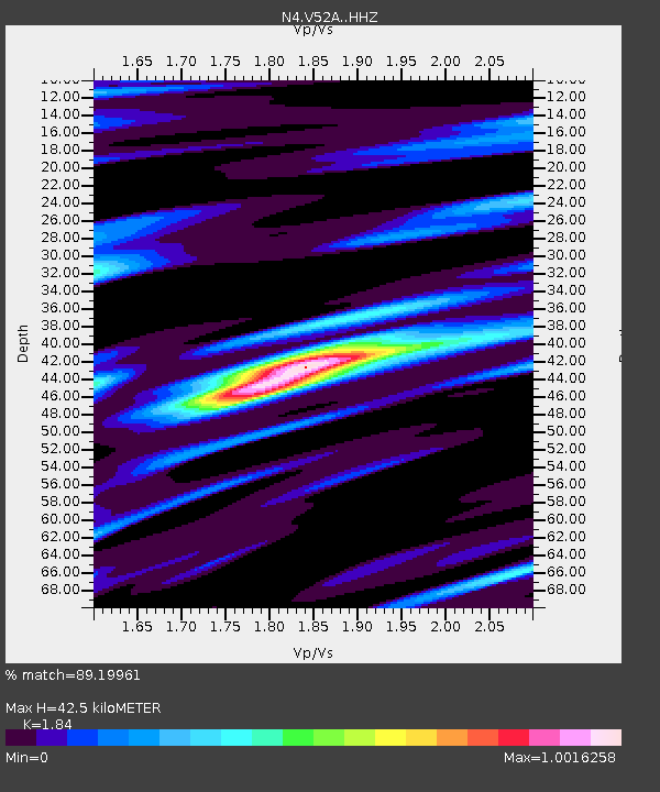
| Estimated Moho Depth: |
42.5 km |
| Estimated Crust Vp/Vs: |
1.84 |
| Assumed Crust Vp: |
6.35 km/s |
| Estimated Crust Vs: |
3.451 km/s |
| Estimated Crust Poisson's Ratio: |
0.29 |
|
| Radial Match: |
89.19961 % |
| Radial Bump: |
400 |
| Transverse Match: |
78.51681 % |
| Transverse Bump: |
400 |
| SOD ConfigId: |
11737051 |
| Insert Time: |
2019-04-25 12:00:13.375 +0000 |
| GWidth: |
2.5 |
| Max Bumps: |
400 |
| Tol: |
0.001 |
|

Signal To Noise
| Channel | StoN | STA | LTA |
| N4:V52A: :HHZ:20160910T10:15:26.149994Z | 23.738344 | 2.5315946E-6 | 1.0664579E-7 |
| N4:V52A: :HHN:20160910T10:15:26.149994Z | 12.981913 | 1.1876821E-6 | 9.148745E-8 |
| N4:V52A: :HHE:20160910T10:15:26.149994Z | 5.234369 | 3.934803E-7 | 7.517244E-8 |
| Arrivals |
| Ps | 6.0 SECOND |
| PpPs | 18 SECOND |
| PsPs/PpSs | 24 SECOND |


