You are here: Home > Network List > OK - Oklahoma Seismic Network Stations List
> Station BLOK Blackwell, Oklahoma, USA > Earthquake Result Viewer
BLOK Blackwell, Oklahoma, USA - Earthquake Result Viewer
| Earthquake location: |
Northern Peru |
| Earthquake latitude/longitude: |
-5.6/-77.0 |
| Earthquake time(UTC): |
2016/09/10 (254) 10:08:20 GMT |
| Earthquake Depth: |
114 km |
| Earthquake Magnitude: |
6.0 MB |
| Earthquake Catalog/Contributor: |
NEIC PDE/NEIC ALERT |
|
| Network: |
OK Oklahoma Seismic Network |
| Station: |
BLOK Blackwell, Oklahoma, USA |
| Lat/Lon: |
36.76 N/97.22 W |
| Elevation: |
301 m |
|
| Distance: |
46.2 deg |
| Az: |
337.344 deg |
| Baz: |
151.483 deg |
| Ray Param: |
0.07041322 |
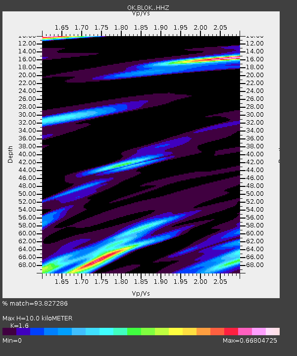
| Estimated Moho Depth: |
10.0 km |
| Estimated Crust Vp/Vs: |
1.60 |
| Assumed Crust Vp: |
6.483 km/s |
| Estimated Crust Vs: |
4.052 km/s |
| Estimated Crust Poisson's Ratio: |
0.18 |
|
| Radial Match: |
93.827286 % |
| Radial Bump: |
400 |
| Transverse Match: |
71.85497 % |
| Transverse Bump: |
400 |
| SOD ConfigId: |
11737051 |
| Insert Time: |
2019-04-25 12:01:26.496 +0000 |
| GWidth: |
2.5 |
| Max Bumps: |
400 |
| Tol: |
0.001 |
|

Signal To Noise
| Channel | StoN | STA | LTA |
| OK:BLOK: :HHZ:20160910T10:16:02.153015Z | 25.674862 | 5.3317544E-6 | 2.076644E-7 |
| OK:BLOK: :HHN:20160910T10:16:02.153015Z | 12.921165 | 2.7736144E-6 | 2.1465667E-7 |
| OK:BLOK: :HHE:20160910T10:16:02.153015Z | 8.462284 | 2.0913637E-6 | 2.471394E-7 |
| Arrivals |
| Ps | 1.0 SECOND |
| PpPs | 3.7 SECOND |
| PsPs/PpSs | 4.7 SECOND |


