You are here: Home > Network List > PE - Penn State Network Stations List
> Station PAPL Promised Land State Park, Greentown, PA > Earthquake Result Viewer
PAPL Promised Land State Park, Greentown, PA - Earthquake Result Viewer
| Earthquake location: |
Northern Peru |
| Earthquake latitude/longitude: |
-5.6/-77.0 |
| Earthquake time(UTC): |
2016/09/10 (254) 10:08:20 GMT |
| Earthquake Depth: |
114 km |
| Earthquake Magnitude: |
6.0 MB |
| Earthquake Catalog/Contributor: |
NEIC PDE/NEIC ALERT |
|
| Network: |
PE Penn State Network |
| Station: |
PAPL Promised Land State Park, Greentown, PA |
| Lat/Lon: |
41.30 N/75.02 W |
| Elevation: |
572 m |
|
| Distance: |
46.7 deg |
| Az: |
2.012 deg |
| Baz: |
182.659 deg |
| Ray Param: |
0.070081905 |
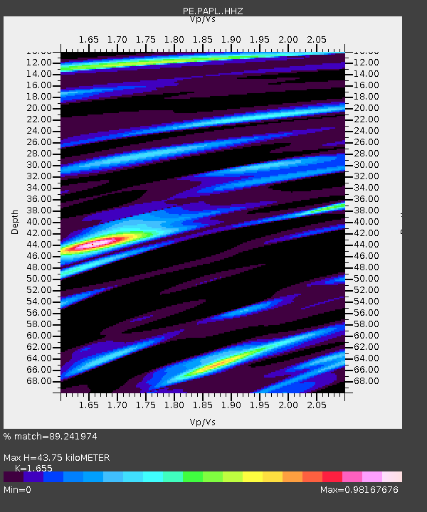
| Estimated Moho Depth: |
43.75 km |
| Estimated Crust Vp/Vs: |
1.65 |
| Assumed Crust Vp: |
6.283 km/s |
| Estimated Crust Vs: |
3.797 km/s |
| Estimated Crust Poisson's Ratio: |
0.21 |
|
| Radial Match: |
89.241974 % |
| Radial Bump: |
273 |
| Transverse Match: |
84.955345 % |
| Transverse Bump: |
400 |
| SOD ConfigId: |
11737051 |
| Insert Time: |
2019-04-25 12:02:05.794 +0000 |
| GWidth: |
2.5 |
| Max Bumps: |
400 |
| Tol: |
0.001 |
|

Signal To Noise
| Channel | StoN | STA | LTA |
| PE:PAPL: :HHZ:20160910T10:16:06.01001Z | 16.404785 | 3.0435383E-6 | 1.8552745E-7 |
| PE:PAPL: :HHN:20160910T10:16:06.01001Z | 9.674321 | 1.3220217E-6 | 1.3665266E-7 |
| PE:PAPL: :HHE:20160910T10:16:06.01001Z | 11.022214 | 6.949047E-7 | 6.304584E-8 |
| Arrivals |
| Ps | 4.9 SECOND |
| PpPs | 17 SECOND |
| PsPs/PpSs | 22 SECOND |


