You are here: Home > Network List > TA - USArray Transportable Network (new EarthScope stations) Stations List
> Station C27K Jago River, AK, USA > Earthquake Result Viewer
C27K Jago River, AK, USA - Earthquake Result Viewer
| Earthquake location: |
Northern Peru |
| Earthquake latitude/longitude: |
-5.6/-77.0 |
| Earthquake time(UTC): |
2016/09/10 (254) 10:08:20 GMT |
| Earthquake Depth: |
114 km |
| Earthquake Magnitude: |
6.0 MB |
| Earthquake Catalog/Contributor: |
NEIC PDE/NEIC ALERT |
|
| Network: |
TA USArray Transportable Network (new EarthScope stations) |
| Station: |
C27K Jago River, AK, USA |
| Lat/Lon: |
69.63 N/143.71 W |
| Elevation: |
392 m |
|
| Distance: |
87.3 deg |
| Az: |
341.209 deg |
| Baz: |
113.726 deg |
| Ray Param: |
0.043183386 |
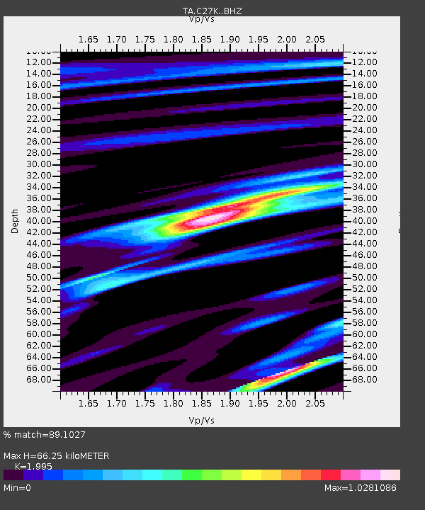
| Estimated Moho Depth: |
66.25 km |
| Estimated Crust Vp/Vs: |
2.00 |
| Assumed Crust Vp: |
6.522 km/s |
| Estimated Crust Vs: |
3.269 km/s |
| Estimated Crust Poisson's Ratio: |
0.33 |
|
| Radial Match: |
89.1027 % |
| Radial Bump: |
400 |
| Transverse Match: |
88.10895 % |
| Transverse Bump: |
398 |
| SOD ConfigId: |
11737051 |
| Insert Time: |
2019-04-25 12:03:12.237 +0000 |
| GWidth: |
2.5 |
| Max Bumps: |
400 |
| Tol: |
0.001 |
|

Signal To Noise
| Channel | StoN | STA | LTA |
| TA:C27K: :BHZ:20160910T10:20:21.950012Z | 20.144493 | 1.7164314E-6 | 8.520598E-8 |
| TA:C27K: :BHN:20160910T10:20:21.950012Z | 5.942718 | 6.172703E-7 | 1.03870036E-7 |
| TA:C27K: :BHE:20160910T10:20:21.950012Z | 5.577986 | 4.907177E-7 | 8.7974E-8 |
| Arrivals |
| Ps | 10 SECOND |
| PpPs | 30 SECOND |
| PsPs/PpSs | 40 SECOND |


