You are here: Home > Network List > US - United States National Seismic Network Stations List
> Station CMB Columbia College, California, USA > Earthquake Result Viewer
CMB Columbia College, California, USA - Earthquake Result Viewer
| Earthquake location: |
Southeast Of Loyalty Islands |
| Earthquake latitude/longitude: |
-22.0/170.6 |
| Earthquake time(UTC): |
2005/04/11 (101) 17:08:53 GMT |
| Earthquake Depth: |
68 km |
| Earthquake Magnitude: |
6.0 MB, 6.8 MW, 6.8 MW |
| Earthquake Catalog/Contributor: |
WHDF/NEIC |
|
| Network: |
US United States National Seismic Network |
| Station: |
CMB Columbia College, California, USA |
| Lat/Lon: |
38.03 N/120.39 W |
| Elevation: |
719 m |
|
| Distance: |
88.0 deg |
| Az: |
47.531 deg |
| Baz: |
240.122 deg |
| Ray Param: |
0.042760268 |
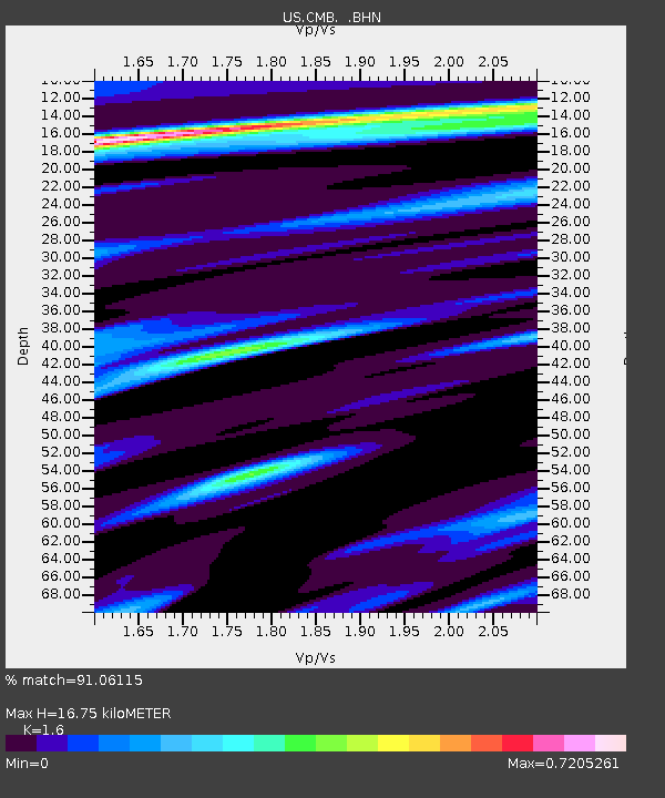
| Estimated Moho Depth: |
16.75 km |
| Estimated Crust Vp/Vs: |
1.60 |
| Assumed Crust Vp: |
6.597 km/s |
| Estimated Crust Vs: |
4.123 km/s |
| Estimated Crust Poisson's Ratio: |
0.18 |
|
| Radial Match: |
91.06115 % |
| Radial Bump: |
363 |
| Transverse Match: |
65.92029 % |
| Transverse Bump: |
400 |
| SOD ConfigId: |
2459 |
| Insert Time: |
2010-03-05 06:52:57.601 +0000 |
| GWidth: |
2.5 |
| Max Bumps: |
400 |
| Tol: |
0.001 |
|

Signal To Noise
| Channel | StoN | STA | LTA |
| US:CMB: :BHN:20050411T17:21:05.533994Z | 0.72185284 | 9.1851895E-8 | 1.2724463E-7 |
| US:CMB: :BHE:20050411T17:21:05.533994Z | 2.6991827 | 2.6988968E-7 | 9.998941E-8 |
| US:CMB: :BHZ:20050411T17:21:05.533994Z | 9.492675 | 1.449966E-6 | 1.5274578E-7 |
| Arrivals |
| Ps | 1.6 SECOND |
| PpPs | 6.4 SECOND |
| PsPs/PpSs | 8.0 SECOND |


