You are here: Home > Network List > TA - USArray Transportable Network (new EarthScope stations) Stations List
> Station F31M Tsiigehtchic, NWT, CAN > Earthquake Result Viewer
F31M Tsiigehtchic, NWT, CAN - Earthquake Result Viewer
| Earthquake location: |
Northern Peru |
| Earthquake latitude/longitude: |
-5.6/-77.0 |
| Earthquake time(UTC): |
2016/09/10 (254) 10:08:20 GMT |
| Earthquake Depth: |
114 km |
| Earthquake Magnitude: |
6.0 MB |
| Earthquake Catalog/Contributor: |
NEIC PDE/NEIC ALERT |
|
| Network: |
TA USArray Transportable Network (new EarthScope stations) |
| Station: |
F31M Tsiigehtchic, NWT, CAN |
| Lat/Lon: |
67.44 N/133.74 W |
| Elevation: |
56 m |
|
| Distance: |
83.0 deg |
| Az: |
341.024 deg |
| Baz: |
122.984 deg |
| Ray Param: |
0.046217613 |
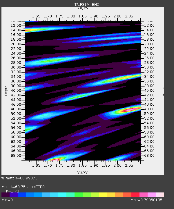
| Estimated Moho Depth: |
69.75 km |
| Estimated Crust Vp/Vs: |
1.73 |
| Assumed Crust Vp: |
6.171 km/s |
| Estimated Crust Vs: |
3.567 km/s |
| Estimated Crust Poisson's Ratio: |
0.25 |
|
| Radial Match: |
80.99373 % |
| Radial Bump: |
358 |
| Transverse Match: |
73.32863 % |
| Transverse Bump: |
380 |
| SOD ConfigId: |
11737051 |
| Insert Time: |
2019-04-25 12:03:24.532 +0000 |
| GWidth: |
2.5 |
| Max Bumps: |
400 |
| Tol: |
0.001 |
|
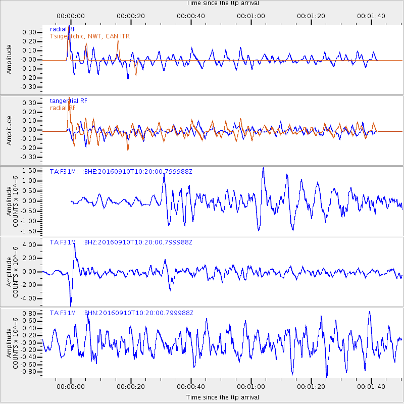
Signal To Noise
| Channel | StoN | STA | LTA |
| TA:F31M: :BHZ:20160910T10:20:00.799988Z | 12.98291 | 2.1147582E-6 | 1.6288784E-7 |
| TA:F31M: :BHN:20160910T10:20:00.799988Z | 1.6130075 | 2.5204997E-7 | 1.5626087E-7 |
| TA:F31M: :BHE:20160910T10:20:00.799988Z | 5.0284348 | 6.901689E-7 | 1.3725324E-7 |
| Arrivals |
| Ps | 8.5 SECOND |
| PpPs | 30 SECOND |
| PsPs/PpSs | 39 SECOND |


