You are here: Home > Network List > TA - USArray Transportable Network (new EarthScope stations) Stations List
> Station H17A Grant Village (NPS), Yellowstone Nt. Park, WY, USA > Earthquake Result Viewer
H17A Grant Village (NPS), Yellowstone Nt. Park, WY, USA - Earthquake Result Viewer
| Earthquake location: |
Northern Peru |
| Earthquake latitude/longitude: |
-5.6/-77.0 |
| Earthquake time(UTC): |
2016/09/10 (254) 10:08:20 GMT |
| Earthquake Depth: |
114 km |
| Earthquake Magnitude: |
6.0 MB |
| Earthquake Catalog/Contributor: |
NEIC PDE/NEIC ALERT |
|
| Network: |
TA USArray Transportable Network (new EarthScope stations) |
| Station: |
H17A Grant Village (NPS), Yellowstone Nt. Park, WY, USA |
| Lat/Lon: |
44.40 N/110.58 W |
| Elevation: |
2400 m |
|
| Distance: |
58.2 deg |
| Az: |
332.168 deg |
| Baz: |
139.592 deg |
| Ray Param: |
0.062653184 |
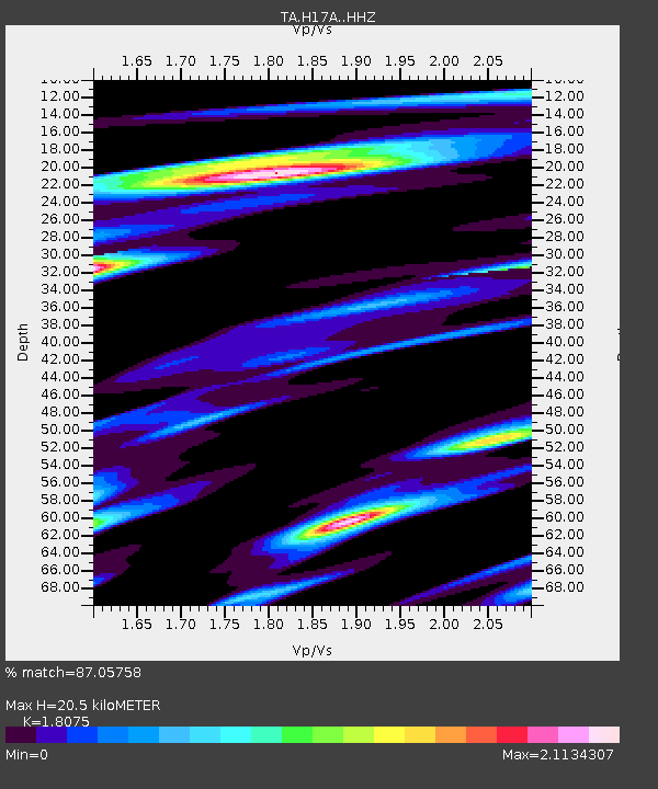
| Estimated Moho Depth: |
20.5 km |
| Estimated Crust Vp/Vs: |
1.81 |
| Assumed Crust Vp: |
6.35 km/s |
| Estimated Crust Vs: |
3.513 km/s |
| Estimated Crust Poisson's Ratio: |
0.28 |
|
| Radial Match: |
87.05758 % |
| Radial Bump: |
400 |
| Transverse Match: |
84.09206 % |
| Transverse Bump: |
400 |
| SOD ConfigId: |
11737051 |
| Insert Time: |
2019-04-25 12:03:34.686 +0000 |
| GWidth: |
2.5 |
| Max Bumps: |
400 |
| Tol: |
0.001 |
|

Signal To Noise
| Channel | StoN | STA | LTA |
| TA:H17A: :HHZ:20160910T10:17:30.820007Z | 23.895649 | 1.4021279E-6 | 5.867712E-8 |
| TA:H17A: :HHN:20160910T10:17:30.820007Z | 22.759089 | 1.7419158E-6 | 7.653715E-8 |
| TA:H17A: :HHE:20160910T10:17:30.820007Z | 20.476126 | 1.2483156E-6 | 6.0964446E-8 |
| Arrivals |
| Ps | 2.7 SECOND |
| PpPs | 8.7 SECOND |
| PsPs/PpSs | 11 SECOND |


