You are here: Home > Network List > TA - USArray Transportable Network (new EarthScope stations) Stations List
> Station M31M Drury Creek, Yukon, CA > Earthquake Result Viewer
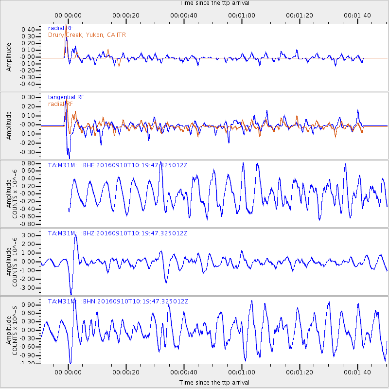
M31M Drury Creek, Yukon, CA - Earthquake Result Viewer
*The percent match for this event was below the threshold and hence no stack was calculated.
| Earthquake location: |
Northern Peru |
| Earthquake latitude/longitude: |
-5.6/-77.0 |
| Earthquake time(UTC): |
2016/09/10 (254) 10:08:20 GMT |
| Earthquake Depth: |
114 km |
| Earthquake Magnitude: |
6.0 MB |
| Earthquake Catalog/Contributor: |
NEIC PDE/NEIC ALERT |
|
| Network: |
TA USArray Transportable Network (new EarthScope stations) |
| Station: |
M31M Drury Creek, Yukon, CA |
| Lat/Lon: |
62.20 N/134.39 W |
| Elevation: |
639 m |
|
| Distance: |
80.5 deg |
| Az: |
336.384 deg |
| Baz: |
121.731 deg |
| Ray Param: |
$rayparam |
*The percent match for this event was below the threshold and hence was not used in the summary stack. |
|
| Radial Match: |
59.29723 % |
| Radial Bump: |
350 |
| Transverse Match: |
74.91645 % |
| Transverse Bump: |
400 |
| SOD ConfigId: |
11737051 |
| Insert Time: |
2019-04-25 12:04:09.850 +0000 |
| GWidth: |
2.5 |
| Max Bumps: |
400 |
| Tol: |
0.001 |
|
Signal To Noise
| Channel | StoN | STA | LTA |
| TA:M31M: :BHZ:20160910T10:19:47.325012Z | 5.75018 | 1.896789E-6 | 3.2986603E-7 |
| TA:M31M: :BHN:20160910T10:19:47.325012Z | 1.7031392 | 6.430118E-7 | 3.7754506E-7 |
| TA:M31M: :BHE:20160910T10:19:47.325012Z | 1.4545721 | 3.8612856E-7 | 2.6545854E-7 |
| Arrivals |
| Ps | |
| PpPs | |
| PsPs/PpSs | |


