You are here: Home > Network List > TA - USArray Transportable Network (new EarthScope stations) Stations List
> Station O17K Koliganek, Bristol Bay, AK, USA > Earthquake Result Viewer
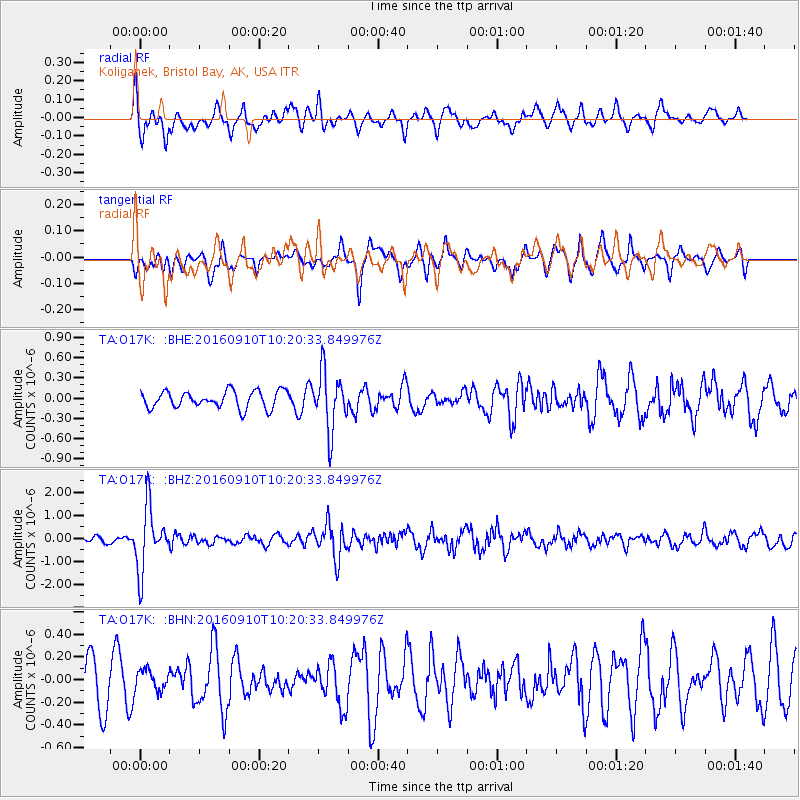
O17K Koliganek, Bristol Bay, AK, USA - Earthquake Result Viewer
*The percent match for this event was below the threshold and hence no stack was calculated.
| Earthquake location: |
Northern Peru |
| Earthquake latitude/longitude: |
-5.6/-77.0 |
| Earthquake time(UTC): |
2016/09/10 (254) 10:08:20 GMT |
| Earthquake Depth: |
114 km |
| Earthquake Magnitude: |
6.0 MB |
| Earthquake Catalog/Contributor: |
NEIC PDE/NEIC ALERT |
|
| Network: |
TA USArray Transportable Network (new EarthScope stations) |
| Station: |
O17K Koliganek, Bristol Bay, AK, USA |
| Lat/Lon: |
59.77 N/157.09 W |
| Elevation: |
156 m |
|
| Distance: |
89.8 deg |
| Az: |
330.102 deg |
| Baz: |
101.307 deg |
| Ray Param: |
$rayparam |
*The percent match for this event was below the threshold and hence was not used in the summary stack. |
|
| Radial Match: |
72.66412 % |
| Radial Bump: |
400 |
| Transverse Match: |
57.314667 % |
| Transverse Bump: |
383 |
| SOD ConfigId: |
11737051 |
| Insert Time: |
2019-04-25 12:04:20.368 +0000 |
| GWidth: |
2.5 |
| Max Bumps: |
400 |
| Tol: |
0.001 |
|
Signal To Noise
| Channel | StoN | STA | LTA |
| TA:O17K: :BHZ:20160910T10:20:33.849976Z | 13.128178 | 1.3774004E-6 | 1.04919394E-7 |
| TA:O17K: :BHN:20160910T10:20:33.849976Z | 0.5407125 | 9.448104E-8 | 1.7473434E-7 |
| TA:O17K: :BHE:20160910T10:20:33.849976Z | 3.3837423 | 4.2771404E-7 | 1.2640265E-7 |
| Arrivals |
| Ps | |
| PpPs | |
| PsPs/PpSs | |


