You are here: Home > Network List > TA - USArray Transportable Network (new EarthScope stations) Stations List
> Station SFIN Lafayette, IN, USA > Earthquake Result Viewer
SFIN Lafayette, IN, USA - Earthquake Result Viewer
| Earthquake location: |
Northern Peru |
| Earthquake latitude/longitude: |
-5.6/-77.0 |
| Earthquake time(UTC): |
2016/09/10 (254) 10:08:20 GMT |
| Earthquake Depth: |
114 km |
| Earthquake Magnitude: |
6.0 MB |
| Earthquake Catalog/Contributor: |
NEIC PDE/NEIC ALERT |
|
| Network: |
TA USArray Transportable Network (new EarthScope stations) |
| Station: |
SFIN Lafayette, IN, USA |
| Lat/Lon: |
40.38 N/87.10 W |
| Elevation: |
165 m |
|
| Distance: |
46.7 deg |
| Az: |
349.355 deg |
| Baz: |
166.073 deg |
| Ray Param: |
0.07008975 |
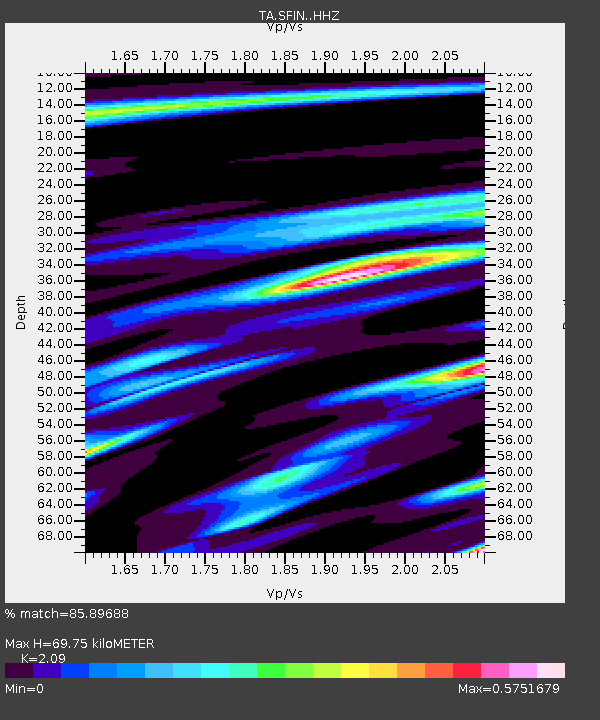
| Estimated Moho Depth: |
69.75 km |
| Estimated Crust Vp/Vs: |
2.09 |
| Assumed Crust Vp: |
6.498 km/s |
| Estimated Crust Vs: |
3.109 km/s |
| Estimated Crust Poisson's Ratio: |
0.35 |
|
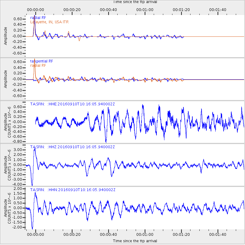
| Radial Match: |
85.89688 % |
| Radial Bump: |
229 |
| Transverse Match: |
70.82644 % |
| Transverse Bump: |
350 |
| SOD ConfigId: |
11737051 |
| Insert Time: |
2019-04-25 12:04:45.786 +0000 |
| GWidth: |
2.5 |
| Max Bumps: |
400 |
| Tol: |
0.001 |
|
Signal To Noise
| Channel | StoN | STA | LTA |
| TA:SFIN: :HHZ:20160910T10:16:05.940002Z | 11.120578 | 1.4391926E-6 | 1.2941707E-7 |
| TA:SFIN: :HHN:20160910T10:16:05.940002Z | 9.982068 | 7.692994E-7 | 7.706814E-8 |
| TA:SFIN: :HHE:20160910T10:16:05.940002Z | 1.9820627 | 2.0709467E-7 | 1.0448442E-7 |
| Arrivals |
| Ps | 12 SECOND |
| PpPs | 31 SECOND |
| PsPs/PpSs | 44 SECOND |


