You are here: Home > Network List > US - United States National Seismic Network Stations List
> Station CMB Columbia College, California, USA > Earthquake Result Viewer
CMB Columbia College, California, USA - Earthquake Result Viewer
| Earthquake location: |
East Of Kuril Islands |
| Earthquake latitude/longitude: |
46.7/155.3 |
| Earthquake time(UTC): |
2006/11/15 (319) 11:34:58 GMT |
| Earthquake Depth: |
10 km |
| Earthquake Magnitude: |
6.4 MB |
| Earthquake Catalog/Contributor: |
WHDF/NEIC |
|
| Network: |
US United States National Seismic Network |
| Station: |
CMB Columbia College, California, USA |
| Lat/Lon: |
38.03 N/120.39 W |
| Elevation: |
719 m |
|
| Distance: |
60.1 deg |
| Az: |
65.029 deg |
| Baz: |
307.737 deg |
| Ray Param: |
0.061764326 |
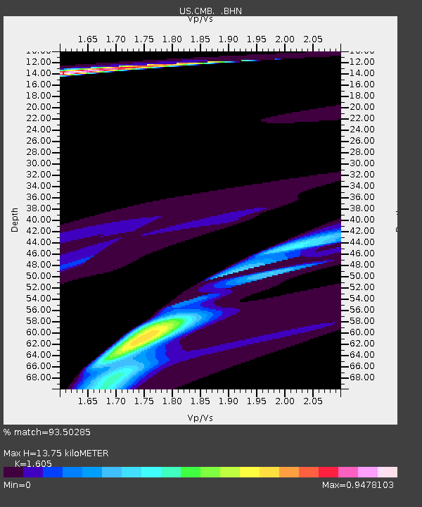
| Estimated Moho Depth: |
13.75 km |
| Estimated Crust Vp/Vs: |
1.61 |
| Assumed Crust Vp: |
6.597 km/s |
| Estimated Crust Vs: |
4.111 km/s |
| Estimated Crust Poisson's Ratio: |
0.18 |
|
| Radial Match: |
93.50285 % |
| Radial Bump: |
400 |
| Transverse Match: |
74.44156 % |
| Transverse Bump: |
400 |
| SOD ConfigId: |
2564 |
| Insert Time: |
2010-03-05 06:53:29.190 +0000 |
| GWidth: |
2.5 |
| Max Bumps: |
400 |
| Tol: |
0.001 |
|

Signal To Noise
| Channel | StoN | STA | LTA |
| US:CMB: :BHN:20061115T11:44:34.247004Z | 2.3505955 | 3.7808208E-5 | 1.6084523E-5 |
| US:CMB: :BHE:20061115T11:44:34.247004Z | 1.1763049 | 3.78068E-5 | 3.2140306E-5 |
| US:CMB: :BHZ:20061115T11:44:34.247004Z | 2.6896122 | 1.2152863E-4 | 4.5184446E-5 |
| Arrivals |
| Ps | 1.3 SECOND |
| PpPs | 5.1 SECOND |
| PsPs/PpSs | 6.5 SECOND |


