You are here: Home > Network List > TA - USArray Transportable Network (new EarthScope stations) Stations List
> Station TPFO Pinon Flats, CA, USA > Earthquake Result Viewer
TPFO Pinon Flats, CA, USA - Earthquake Result Viewer
| Earthquake location: |
Northern Peru |
| Earthquake latitude/longitude: |
-5.6/-77.0 |
| Earthquake time(UTC): |
2016/09/10 (254) 10:08:20 GMT |
| Earthquake Depth: |
114 km |
| Earthquake Magnitude: |
6.0 MB |
| Earthquake Catalog/Contributor: |
NEIC PDE/NEIC ALERT |
|
| Network: |
TA USArray Transportable Network (new EarthScope stations) |
| Station: |
TPFO Pinon Flats, CA, USA |
| Lat/Lon: |
33.61 N/116.45 W |
| Elevation: |
1275 m |
|
| Distance: |
54.0 deg |
| Az: |
319.001 deg |
| Baz: |
128.519 deg |
| Ray Param: |
0.06537628 |
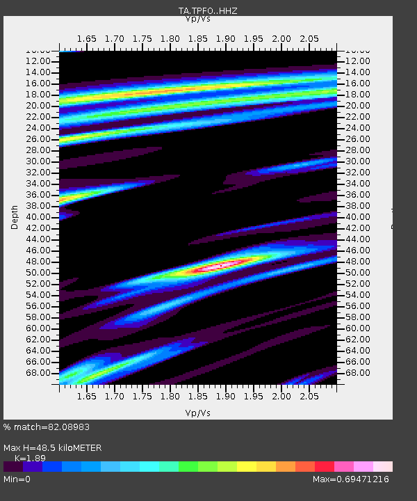
| Estimated Moho Depth: |
48.5 km |
| Estimated Crust Vp/Vs: |
1.89 |
| Assumed Crust Vp: |
6.264 km/s |
| Estimated Crust Vs: |
3.314 km/s |
| Estimated Crust Poisson's Ratio: |
0.31 |
|
| Radial Match: |
82.08983 % |
| Radial Bump: |
400 |
| Transverse Match: |
62.58993 % |
| Transverse Bump: |
380 |
| SOD ConfigId: |
11737051 |
| Insert Time: |
2019-04-25 12:04:52.070 +0000 |
| GWidth: |
2.5 |
| Max Bumps: |
400 |
| Tol: |
0.001 |
|
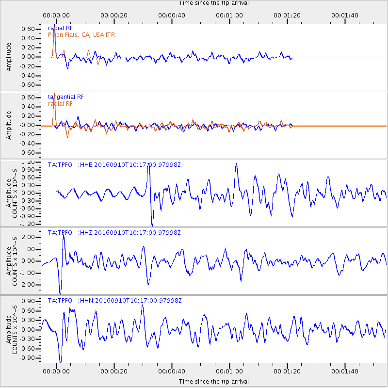
Signal To Noise
| Channel | StoN | STA | LTA |
| TA:TPFO: :HHZ:20160910T10:17:00.97998Z | 6.9356527 | 1.2534772E-6 | 1.8072951E-7 |
| TA:TPFO: :HHN:20160910T10:17:00.97998Z | 2.918413 | 5.0425706E-7 | 1.7278468E-7 |
| TA:TPFO: :HHE:20160910T10:17:00.97998Z | 5.491768 | 6.1834226E-7 | 1.1259439E-7 |
| Arrivals |
| Ps | 7.2 SECOND |
| PpPs | 21 SECOND |
| PsPs/PpSs | 29 SECOND |


