You are here: Home > Network List > US - United States National Seismic Network Stations List
> Station CMB Columbia College, California, USA > Earthquake Result Viewer
CMB Columbia College, California, USA - Earthquake Result Viewer
| Earthquake location: |
Gulf Of Mexico |
| Earthquake latitude/longitude: |
26.3/-86.6 |
| Earthquake time(UTC): |
2006/09/10 (253) 14:56:08 GMT |
| Earthquake Depth: |
14 km |
| Earthquake Magnitude: |
5.9 MB, 5.5 MS, 5.8 MW, 5.8 MW |
| Earthquake Catalog/Contributor: |
WHDF/NEIC |
|
| Network: |
US United States National Seismic Network |
| Station: |
CMB Columbia College, California, USA |
| Lat/Lon: |
38.03 N/120.39 W |
| Elevation: |
719 m |
|
| Distance: |
30.7 deg |
| Az: |
300.756 deg |
| Baz: |
102.378 deg |
| Ray Param: |
0.07925229 |
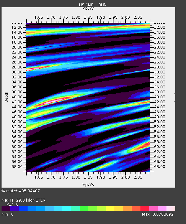
| Estimated Moho Depth: |
29.0 km |
| Estimated Crust Vp/Vs: |
1.60 |
| Assumed Crust Vp: |
6.597 km/s |
| Estimated Crust Vs: |
4.123 km/s |
| Estimated Crust Poisson's Ratio: |
0.18 |
|
| Radial Match: |
85.34487 % |
| Radial Bump: |
400 |
| Transverse Match: |
53.87944 % |
| Transverse Bump: |
358 |
| SOD ConfigId: |
2564 |
| Insert Time: |
2010-03-05 06:53:33.279 +0000 |
| GWidth: |
2.5 |
| Max Bumps: |
400 |
| Tol: |
0.001 |
|

Signal To Noise
| Channel | StoN | STA | LTA |
| US:CMB: :BHN:20060910T15:01:51.972012Z | 2.765692 | 1.5360466E-7 | 5.5539324E-8 |
| US:CMB: :BHE:20060910T15:01:51.972012Z | 3.2038696 | 2.7656372E-7 | 8.6321776E-8 |
| US:CMB: :BHZ:20060910T15:01:51.972012Z | 4.572215 | 5.1264453E-7 | 1.12121704E-7 |
| Arrivals |
| Ps | 2.9 SECOND |
| PpPs | 10 SECOND |
| PsPs/PpSs | 13 SECOND |


