You are here: Home > Network List > UW - Pacific Northwest Regional Seismic Network Stations List
> Station FISH Seaside, OR, USA > Earthquake Result Viewer
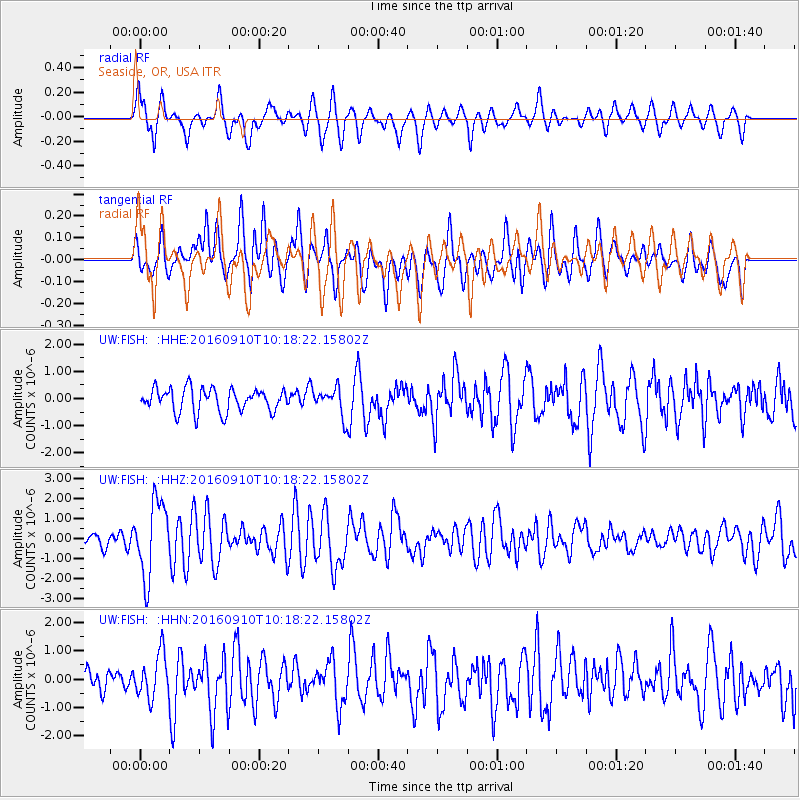
FISH Seaside, OR, USA - Earthquake Result Viewer
*The percent match for this event was below the threshold and hence no stack was calculated.
| Earthquake location: |
Northern Peru |
| Earthquake latitude/longitude: |
-5.6/-77.0 |
| Earthquake time(UTC): |
2016/09/10 (254) 10:08:20 GMT |
| Earthquake Depth: |
114 km |
| Earthquake Magnitude: |
6.0 MB |
| Earthquake Catalog/Contributor: |
NEIC PDE/NEIC ALERT |
|
| Network: |
UW Pacific Northwest Regional Seismic Network |
| Station: |
FISH Seaside, OR, USA |
| Lat/Lon: |
45.93 N/123.56 W |
| Elevation: |
325 m |
|
| Distance: |
65.9 deg |
| Az: |
326.26 deg |
| Baz: |
127.62 deg |
| Ray Param: |
$rayparam |
*The percent match for this event was below the threshold and hence was not used in the summary stack. |
|
| Radial Match: |
76.79054 % |
| Radial Bump: |
400 |
| Transverse Match: |
72.7253 % |
| Transverse Bump: |
400 |
| SOD ConfigId: |
11737051 |
| Insert Time: |
2019-04-25 12:05:16.789 +0000 |
| GWidth: |
2.5 |
| Max Bumps: |
400 |
| Tol: |
0.001 |
|
Signal To Noise
| Channel | StoN | STA | LTA |
| UW:FISH: :HHZ:20160910T10:18:22.15802Z | 5.1546035 | 1.8731386E-6 | 3.633914E-7 |
| UW:FISH: :HHN:20160910T10:18:22.15802Z | 1.8832229 | 7.916603E-7 | 4.2037524E-7 |
| UW:FISH: :HHE:20160910T10:18:22.15802Z | 1.5450914 | 6.543931E-7 | 4.2353034E-7 |
| Arrivals |
| Ps | |
| PpPs | |
| PsPs/PpSs | |


