You are here: Home > Network List > UW - Pacific Northwest Regional Seismic Network Stations List
> Station RADR Rader Ridge, WA > Earthquake Result Viewer
RADR Rader Ridge, WA - Earthquake Result Viewer
| Earthquake location: |
Northern Peru |
| Earthquake latitude/longitude: |
-5.6/-77.0 |
| Earthquake time(UTC): |
2016/09/10 (254) 10:08:20 GMT |
| Earthquake Depth: |
114 km |
| Earthquake Magnitude: |
6.0 MB |
| Earthquake Catalog/Contributor: |
NEIC PDE/NEIC ALERT |
|
| Network: |
UW Pacific Northwest Regional Seismic Network |
| Station: |
RADR Rader Ridge, WA |
| Lat/Lon: |
46.42 N/123.80 W |
| Elevation: |
568 m |
|
| Distance: |
66.3 deg |
| Az: |
326.575 deg |
| Baz: |
127.574 deg |
| Ray Param: |
0.057367858 |
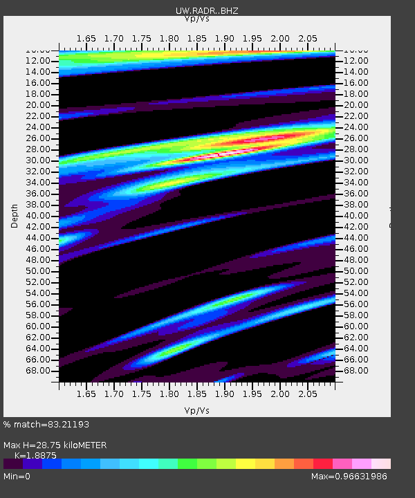
| Estimated Moho Depth: |
28.75 km |
| Estimated Crust Vp/Vs: |
1.89 |
| Assumed Crust Vp: |
6.566 km/s |
| Estimated Crust Vs: |
3.479 km/s |
| Estimated Crust Poisson's Ratio: |
0.30 |
|
| Radial Match: |
83.21193 % |
| Radial Bump: |
382 |
| Transverse Match: |
73.9304 % |
| Transverse Bump: |
400 |
| SOD ConfigId: |
11737051 |
| Insert Time: |
2019-04-25 12:05:29.067 +0000 |
| GWidth: |
2.5 |
| Max Bumps: |
400 |
| Tol: |
0.001 |
|

Signal To Noise
| Channel | StoN | STA | LTA |
| UW:RADR: :BHZ:20160910T10:18:24.914978Z | 10.498797 | 2.5966858E-6 | 2.4733174E-7 |
| UW:RADR: :BHN:20160910T10:18:24.914978Z | 1.8991535 | 5.6762343E-7 | 2.9888233E-7 |
| UW:RADR: :BHE:20160910T10:18:24.914978Z | 4.4865685 | 1.0768938E-6 | 2.4002617E-7 |
| Arrivals |
| Ps | 4.0 SECOND |
| PpPs | 12 SECOND |
| PsPs/PpSs | 16 SECOND |


