You are here: Home > Network List > YT07 - POLENET Stations List
> Station DNTW DNTW > Earthquake Result Viewer
DNTW DNTW - Earthquake Result Viewer
| Earthquake location: |
Northern Peru |
| Earthquake latitude/longitude: |
-5.6/-77.0 |
| Earthquake time(UTC): |
2016/09/10 (254) 10:08:20 GMT |
| Earthquake Depth: |
114 km |
| Earthquake Magnitude: |
6.0 MB |
| Earthquake Catalog/Contributor: |
NEIC PDE/NEIC ALERT |
|
| Network: |
YT POLENET |
| Station: |
DNTW DNTW |
| Lat/Lon: |
76.45 S/107.78 W |
| Elevation: |
1031 m |
|
| Distance: |
72.8 deg |
| Az: |
187.262 deg |
| Baz: |
32.252 deg |
| Ray Param: |
0.053133637 |
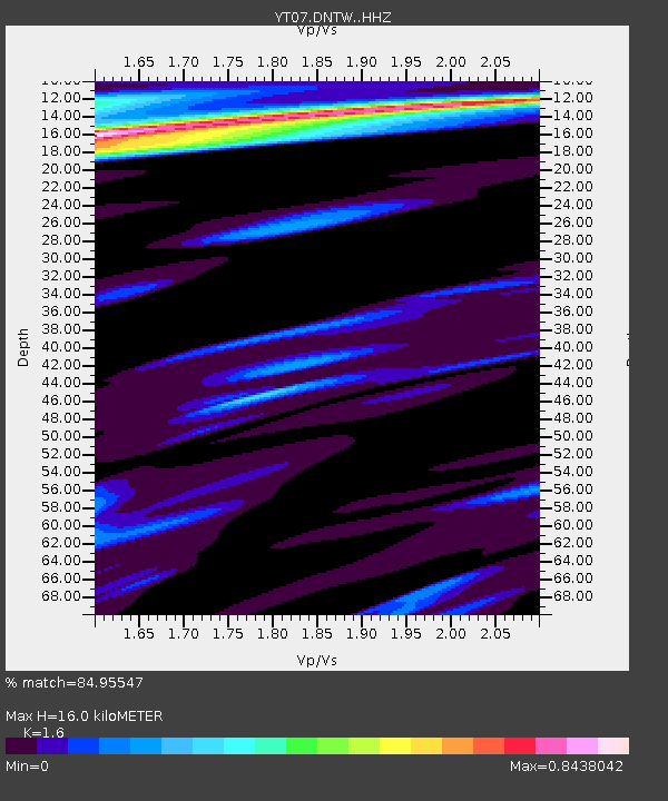
| Estimated Moho Depth: |
16.0 km |
| Estimated Crust Vp/Vs: |
1.60 |
| Assumed Crust Vp: |
5.951 km/s |
| Estimated Crust Vs: |
3.719 km/s |
| Estimated Crust Poisson's Ratio: |
0.18 |
|
| Radial Match: |
84.95547 % |
| Radial Bump: |
390 |
| Transverse Match: |
65.887 % |
| Transverse Bump: |
371 |
| SOD ConfigId: |
11737051 |
| Insert Time: |
2019-04-25 12:07:13.493 +0000 |
| GWidth: |
2.5 |
| Max Bumps: |
400 |
| Tol: |
0.001 |
|

Signal To Noise
| Channel | StoN | STA | LTA |
| YT:DNTW: :HHZ:20160910T10:19:04.598999Z | 9.592409 | 1.4950267E-6 | 1.5585519E-7 |
| YT:DNTW: :HHN:20160910T10:19:04.598999Z | 2.012542 | 3.3819185E-7 | 1.6804215E-7 |
| YT:DNTW: :HHE:20160910T10:19:04.598999Z | 0.79354024 | 1.18122124E-7 | 1.4885461E-7 |
| Arrivals |
| Ps | 1.7 SECOND |
| PpPs | 6.8 SECOND |
| PsPs/PpSs | 8.4 SECOND |


