You are here: Home > Network List > YT07 - POLENET Stations List
> Station MA06 Polenet mini-array MA06 > Earthquake Result Viewer
MA06 Polenet mini-array MA06 - Earthquake Result Viewer
| Earthquake location: |
Northern Peru |
| Earthquake latitude/longitude: |
-5.6/-77.0 |
| Earthquake time(UTC): |
2016/09/10 (254) 10:08:20 GMT |
| Earthquake Depth: |
114 km |
| Earthquake Magnitude: |
6.0 MB |
| Earthquake Catalog/Contributor: |
NEIC PDE/NEIC ALERT |
|
| Network: |
YT POLENET |
| Station: |
MA06 Polenet mini-array MA06 |
| Lat/Lon: |
79.44 S/97.56 W |
| Elevation: |
1949 m |
|
| Distance: |
74.5 deg |
| Az: |
183.86 deg |
| Baz: |
21.301 deg |
| Ray Param: |
0.05199718 |
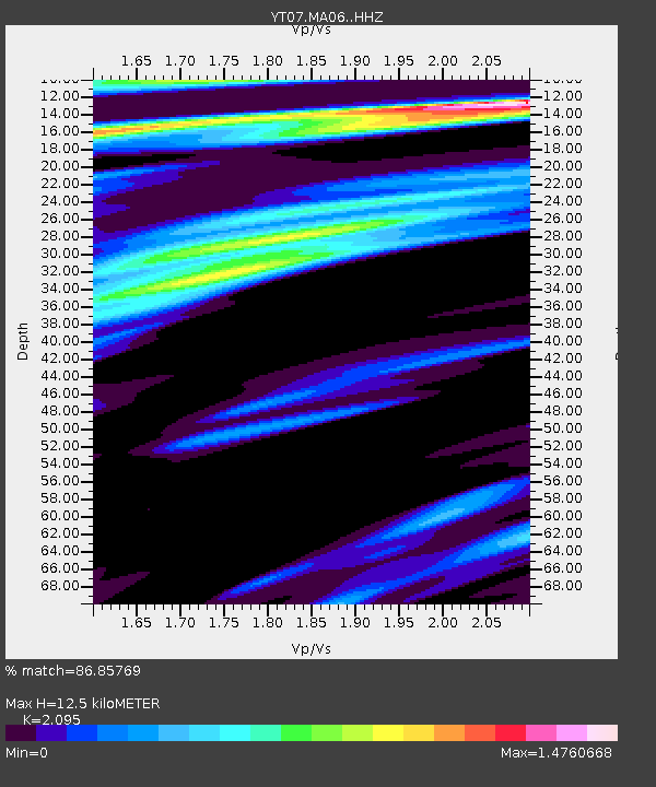
| Estimated Moho Depth: |
12.5 km |
| Estimated Crust Vp/Vs: |
2.10 |
| Assumed Crust Vp: |
5.833 km/s |
| Estimated Crust Vs: |
2.784 km/s |
| Estimated Crust Poisson's Ratio: |
0.35 |
|
| Radial Match: |
86.85769 % |
| Radial Bump: |
400 |
| Transverse Match: |
83.68802 % |
| Transverse Bump: |
389 |
| SOD ConfigId: |
11737051 |
| Insert Time: |
2019-04-25 12:07:21.147 +0000 |
| GWidth: |
2.5 |
| Max Bumps: |
400 |
| Tol: |
0.001 |
|

Signal To Noise
| Channel | StoN | STA | LTA |
| YT:MA06: :HHZ:20160910T10:19:14.539001Z | 2.7296853 | 2.1771143E-6 | 7.9756967E-7 |
| YT:MA06: :HHN:20160910T10:19:14.539001Z | 1.1452099 | 1.1096109E-6 | 9.68915E-7 |
| YT:MA06: :HHE:20160910T10:19:14.539001Z | 1.1493014 | 5.3019124E-7 | 4.6131615E-7 |
| Arrivals |
| Ps | 2.4 SECOND |
| PpPs | 6.5 SECOND |
| PsPs/PpSs | 8.9 SECOND |


