You are here: Home > Network List > GS - US Geological Survey Networks Stations List
> Station KAN11 Stewart Ranch, Harper County, KS, USA > Earthquake Result Viewer
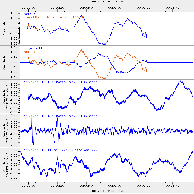
KAN11 Stewart Ranch, Harper County, KS, USA - Earthquake Result Viewer
*The percent match for this event was below the threshold and hence no stack was calculated.
| Earthquake location: |
Near Coast Of Central Chile |
| Earthquake latitude/longitude: |
-31.5/-71.2 |
| Earthquake time(UTC): |
2015/09/22 (265) 07:12:59 GMT |
| Earthquake Depth: |
54 km |
| Earthquake Magnitude: |
6.1 MWB |
| Earthquake Catalog/Contributor: |
NEIC PDE/NEIC COMCAT |
|
| Network: |
GS US Geological Survey Networks |
| Station: |
KAN11 Stewart Ranch, Harper County, KS, USA |
| Lat/Lon: |
37.21 N/97.91 W |
| Elevation: |
410 m |
|
| Distance: |
72.8 deg |
| Az: |
337.923 deg |
| Baz: |
156.284 deg |
| Ray Param: |
$rayparam |
*The percent match for this event was below the threshold and hence was not used in the summary stack. |
|
| Radial Match: |
32.151443 % |
| Radial Bump: |
400 |
| Transverse Match: |
55.418926 % |
| Transverse Bump: |
400 |
| SOD ConfigId: |
1156111 |
| Insert Time: |
2015-10-06 07:45:10.880 +0000 |
| GWidth: |
2.5 |
| Max Bumps: |
400 |
| Tol: |
0.001 |
|
Signal To Noise
| Channel | StoN | STA | LTA |
| GS:KAN11:01:HHZ:20150922T07:23:51.490027Z | 7.111918 | 1.7212217E-6 | 2.4201935E-7 |
| GS:KAN11:01:HHN:20150922T07:23:51.490027Z | 0.5385606 | 7.3535506E-7 | 1.3654081E-6 |
| GS:KAN11:01:HHE:20150922T07:23:51.490027Z | 0.45133367 | 4.9987756E-7 | 1.1075565E-6 |
| Arrivals |
| Ps | |
| PpPs | |
| PsPs/PpSs | |


