You are here: Home > Network List > TJ - Tajikistan National Seismic Network Stations List
> Station CHGR Chuyangaron, Tajikistan > Earthquake Result Viewer
CHGR Chuyangaron, Tajikistan - Earthquake Result Viewer
| Earthquake location: |
Lake Victoria Region |
| Earthquake latitude/longitude: |
-1.0/31.5 |
| Earthquake time(UTC): |
2016/09/10 (254) 12:27:28 GMT |
| Earthquake Depth: |
10 km |
| Earthquake Magnitude: |
5.9 MWW, 5.8 MWB, 5.9 MWC |
| Earthquake Catalog/Contributor: |
NEIC PDE/NEIC COMCAT |
|
| Network: |
TJ Tajikistan National Seismic Network |
| Station: |
CHGR Chuyangaron, Tajikistan |
| Lat/Lon: |
38.66 N/69.16 E |
| Elevation: |
1049 m |
|
| Distance: |
52.5 deg |
| Az: |
37.043 deg |
| Baz: |
230.291 deg |
| Ray Param: |
0.06672949 |
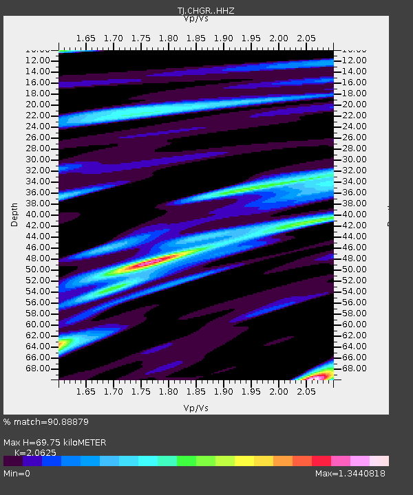
| Estimated Moho Depth: |
69.75 km |
| Estimated Crust Vp/Vs: |
2.06 |
| Assumed Crust Vp: |
6.483 km/s |
| Estimated Crust Vs: |
3.143 km/s |
| Estimated Crust Poisson's Ratio: |
0.35 |
|
| Radial Match: |
90.88879 % |
| Radial Bump: |
400 |
| Transverse Match: |
75.791626 % |
| Transverse Bump: |
400 |
| SOD ConfigId: |
11737051 |
| Insert Time: |
2019-04-25 12:11:23.084 +0000 |
| GWidth: |
2.5 |
| Max Bumps: |
400 |
| Tol: |
0.001 |
|

Signal To Noise
| Channel | StoN | STA | LTA |
| TJ:CHGR: :HHZ:20160910T12:36:11.450029Z | 3.6167245 | 4.6979974E-7 | 1.2989646E-7 |
| TJ:CHGR: :HHN:20160910T12:36:11.450029Z | 2.3590815 | 1.8375451E-7 | 7.7892395E-8 |
| TJ:CHGR: :HHE:20160910T12:36:11.450029Z | 1.9669412 | 1.7937852E-7 | 9.119668E-8 |
| Arrivals |
| Ps | 12 SECOND |
| PpPs | 31 SECOND |
| PsPs/PpSs | 43 SECOND |


