You are here: Home > Network List > TJ - Tajikistan National Seismic Network Stations List
> Station GARM Garm, Tajikistan > Earthquake Result Viewer
GARM Garm, Tajikistan - Earthquake Result Viewer
| Earthquake location: |
Lake Victoria Region |
| Earthquake latitude/longitude: |
-1.0/31.5 |
| Earthquake time(UTC): |
2016/09/10 (254) 12:27:28 GMT |
| Earthquake Depth: |
10 km |
| Earthquake Magnitude: |
5.9 MWW, 5.8 MWB, 5.9 MWC |
| Earthquake Catalog/Contributor: |
NEIC PDE/NEIC COMCAT |
|
| Network: |
TJ Tajikistan National Seismic Network |
| Station: |
GARM Garm, Tajikistan |
| Lat/Lon: |
39.00 N/70.32 E |
| Elevation: |
1305 m |
|
| Distance: |
53.4 deg |
| Az: |
37.427 deg |
| Baz: |
231.245 deg |
| Ray Param: |
0.06612415 |
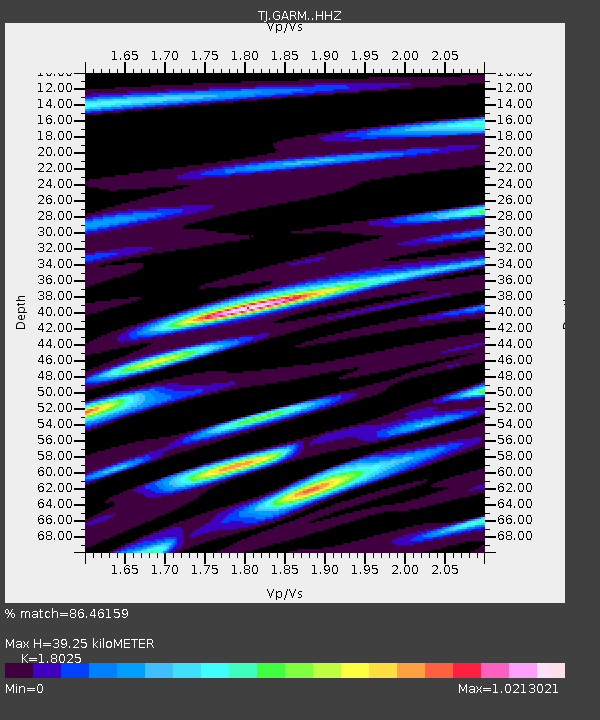
| Estimated Moho Depth: |
39.25 km |
| Estimated Crust Vp/Vs: |
1.80 |
| Assumed Crust Vp: |
6.306 km/s |
| Estimated Crust Vs: |
3.498 km/s |
| Estimated Crust Poisson's Ratio: |
0.28 |
|
| Radial Match: |
86.46159 % |
| Radial Bump: |
391 |
| Transverse Match: |
72.89419 % |
| Transverse Bump: |
400 |
| SOD ConfigId: |
11737051 |
| Insert Time: |
2019-04-25 12:11:23.954 +0000 |
| GWidth: |
2.5 |
| Max Bumps: |
400 |
| Tol: |
0.001 |
|
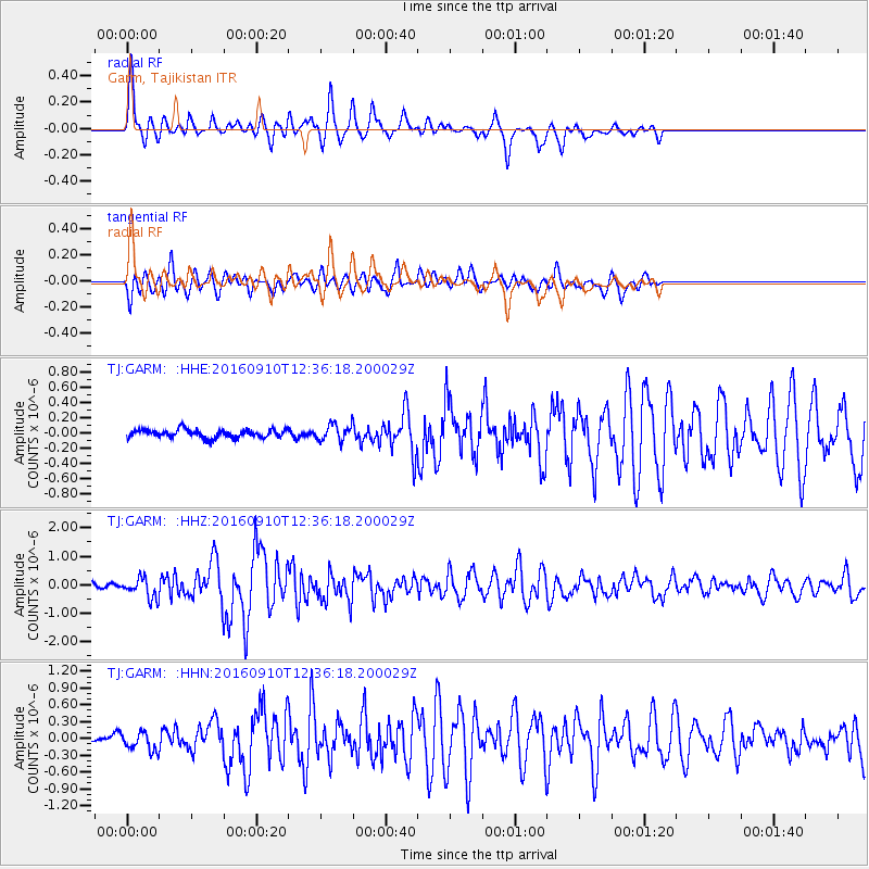
Signal To Noise
| Channel | StoN | STA | LTA |
| TJ:GARM: :HHZ:20160910T12:36:18.200029Z | 3.9018729 | 3.5418748E-7 | 9.077371E-8 |
| TJ:GARM: :HHN:20160910T12:36:18.200029Z | 1.9503299 | 1.6427053E-7 | 8.4227054E-8 |
| TJ:GARM: :HHE:20160910T12:36:18.200029Z | 1.8874875 | 1.0056984E-7 | 5.328239E-8 |
| Arrivals |
| Ps | 5.3 SECOND |
| PpPs | 17 SECOND |
| PsPs/PpSs | 22 SECOND |


