You are here: Home > Network List > TJ - Tajikistan National Seismic Network Stations List
> Station SHAA Shaartuz, Tajikistan > Earthquake Result Viewer
SHAA Shaartuz, Tajikistan - Earthquake Result Viewer
| Earthquake location: |
Lake Victoria Region |
| Earthquake latitude/longitude: |
-1.0/31.5 |
| Earthquake time(UTC): |
2016/09/10 (254) 12:27:28 GMT |
| Earthquake Depth: |
10 km |
| Earthquake Magnitude: |
5.9 MWW, 5.8 MWB, 5.9 MWC |
| Earthquake Catalog/Contributor: |
NEIC PDE/NEIC COMCAT |
|
| Network: |
TJ Tajikistan National Seismic Network |
| Station: |
SHAA Shaartuz, Tajikistan |
| Lat/Lon: |
37.56 N/68.12 E |
| Elevation: |
868 m |
|
| Distance: |
51.2 deg |
| Az: |
37.443 deg |
| Baz: |
229.902 deg |
| Ray Param: |
0.067589834 |
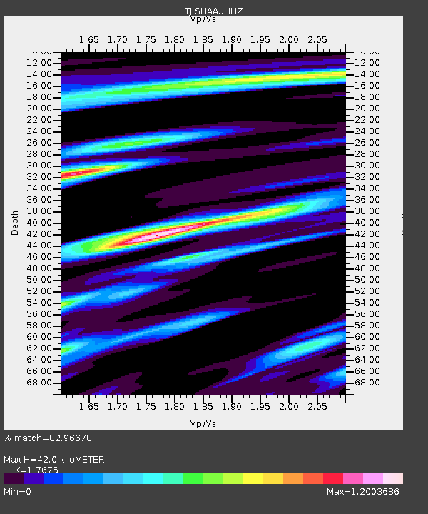
| Estimated Moho Depth: |
42.0 km |
| Estimated Crust Vp/Vs: |
1.77 |
| Assumed Crust Vp: |
6.213 km/s |
| Estimated Crust Vs: |
3.515 km/s |
| Estimated Crust Poisson's Ratio: |
0.26 |
|
| Radial Match: |
82.96678 % |
| Radial Bump: |
400 |
| Transverse Match: |
69.56125 % |
| Transverse Bump: |
400 |
| SOD ConfigId: |
11737051 |
| Insert Time: |
2019-04-25 12:11:26.061 +0000 |
| GWidth: |
2.5 |
| Max Bumps: |
400 |
| Tol: |
0.001 |
|
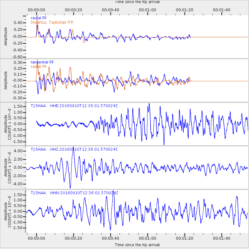
Signal To Noise
| Channel | StoN | STA | LTA |
| TJ:SHAA: :HHZ:20160910T12:36:01.570024Z | 3.4772978 | 5.488436E-7 | 1.5783624E-7 |
| TJ:SHAA: :HHN:20160910T12:36:01.570024Z | 2.153134 | 2.5369675E-7 | 1.1782674E-7 |
| TJ:SHAA: :HHE:20160910T12:36:01.570024Z | 2.0841627 | 2.3076429E-7 | 1.1072279E-7 |
| Arrivals |
| Ps | 5.5 SECOND |
| PpPs | 18 SECOND |
| PsPs/PpSs | 23 SECOND |


