You are here: Home > Network List > CI - Caltech Regional Seismic Network Stations List
> Station MPM Manuel Prospect Mine, California, USA > Earthquake Result Viewer
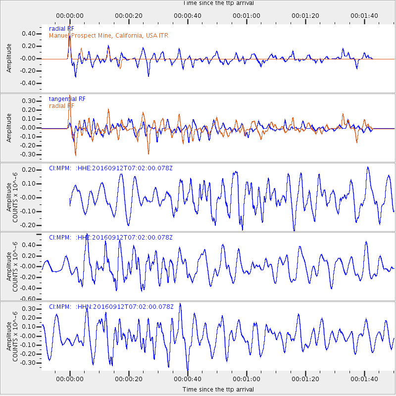
MPM Manuel Prospect Mine, California, USA - Earthquake Result Viewer
*The percent match for this event was below the threshold and hence no stack was calculated.
| Earthquake location: |
Easter Island Region |
| Earthquake latitude/longitude: |
-28.8/-112.3 |
| Earthquake time(UTC): |
2016/09/12 (256) 06:51:53 GMT |
| Earthquake Depth: |
10 km |
| Earthquake Magnitude: |
5.8 mww |
| Earthquake Catalog/Contributor: |
NEIC PDE/us |
|
| Network: |
CI Caltech Regional Seismic Network |
| Station: |
MPM Manuel Prospect Mine, California, USA |
| Lat/Lon: |
36.06 N/117.49 W |
| Elevation: |
185 m |
|
| Distance: |
64.7 deg |
| Az: |
355.353 deg |
| Baz: |
174.964 deg |
| Ray Param: |
$rayparam |
*The percent match for this event was below the threshold and hence was not used in the summary stack. |
|
| Radial Match: |
66.96121 % |
| Radial Bump: |
400 |
| Transverse Match: |
56.908886 % |
| Transverse Bump: |
400 |
| SOD ConfigId: |
11737051 |
| Insert Time: |
2019-04-25 12:14:47.407 +0000 |
| GWidth: |
2.5 |
| Max Bumps: |
400 |
| Tol: |
0.001 |
|
Signal To Noise
| Channel | StoN | STA | LTA |
| CI:MPM: :HHZ:20160912T07:02:00.078Z | 2.6297119 | 1.6877024E-7 | 6.4178224E-8 |
| CI:MPM: :HHN:20160912T07:02:00.078Z | 0.49545795 | 4.8776887E-8 | 9.844808E-8 |
| CI:MPM: :HHE:20160912T07:02:00.078Z | 0.43829077 | 3.873449E-8 | 8.837624E-8 |
| Arrivals |
| Ps | |
| PpPs | |
| PsPs/PpSs | |


