You are here: Home > Network List > IW - Intermountain West Stations List
> Station MOOW Moose Ponds, Wyoming, USA > Earthquake Result Viewer
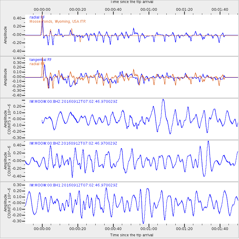
MOOW Moose Ponds, Wyoming, USA - Earthquake Result Viewer
*The percent match for this event was below the threshold and hence no stack was calculated.
| Earthquake location: |
Easter Island Region |
| Earthquake latitude/longitude: |
-28.8/-112.3 |
| Earthquake time(UTC): |
2016/09/12 (256) 06:51:53 GMT |
| Earthquake Depth: |
10 km |
| Earthquake Magnitude: |
5.8 mww |
| Earthquake Catalog/Contributor: |
NEIC PDE/us |
|
| Network: |
IW Intermountain West |
| Station: |
MOOW Moose Ponds, Wyoming, USA |
| Lat/Lon: |
43.75 N/110.74 W |
| Elevation: |
2128 m |
|
| Distance: |
72.2 deg |
| Az: |
1.188 deg |
| Baz: |
181.439 deg |
| Ray Param: |
$rayparam |
*The percent match for this event was below the threshold and hence was not used in the summary stack. |
|
| Radial Match: |
59.50167 % |
| Radial Bump: |
306 |
| Transverse Match: |
46.10943 % |
| Transverse Bump: |
400 |
| SOD ConfigId: |
11737051 |
| Insert Time: |
2019-04-25 12:16:26.355 +0000 |
| GWidth: |
2.5 |
| Max Bumps: |
400 |
| Tol: |
0.001 |
|
Signal To Noise
| Channel | StoN | STA | LTA |
| IW:MOOW:00:BHZ:20160912T07:02:46.970029Z | 2.5724583 | 1.6891772E-7 | 6.566393E-8 |
| IW:MOOW:00:BH1:20160912T07:02:46.970029Z | 0.96701086 | 8.281922E-8 | 8.5644565E-8 |
| IW:MOOW:00:BH2:20160912T07:02:46.970029Z | 0.6971879 | 4.3734314E-8 | 6.27296E-8 |
| Arrivals |
| Ps | |
| PpPs | |
| PsPs/PpSs | |


