You are here: Home > Network List > US - United States National Seismic Network Stations List
> Station MSO Missoula, Montana, USA > Earthquake Result Viewer
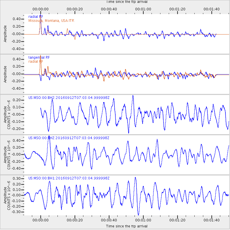
MSO Missoula, Montana, USA - Earthquake Result Viewer
*The percent match for this event was below the threshold and hence no stack was calculated.
| Earthquake location: |
Easter Island Region |
| Earthquake latitude/longitude: |
-28.8/-112.3 |
| Earthquake time(UTC): |
2016/09/12 (256) 06:51:53 GMT |
| Earthquake Depth: |
10 km |
| Earthquake Magnitude: |
5.8 mww |
| Earthquake Catalog/Contributor: |
NEIC PDE/us |
|
| Network: |
US United States National Seismic Network |
| Station: |
MSO Missoula, Montana, USA |
| Lat/Lon: |
46.83 N/113.94 W |
| Elevation: |
1264 m |
|
| Distance: |
75.2 deg |
| Az: |
358.839 deg |
| Baz: |
178.515 deg |
| Ray Param: |
$rayparam |
*The percent match for this event was below the threshold and hence was not used in the summary stack. |
|
| Radial Match: |
61.48802 % |
| Radial Bump: |
400 |
| Transverse Match: |
51.130524 % |
| Transverse Bump: |
400 |
| SOD ConfigId: |
11737051 |
| Insert Time: |
2019-04-25 12:20:29.931 +0000 |
| GWidth: |
2.5 |
| Max Bumps: |
400 |
| Tol: |
0.001 |
|
Signal To Noise
| Channel | StoN | STA | LTA |
| US:MSO:00:BHZ:20160912T07:03:04.999998Z | 2.1210315 | 2.1797057E-7 | 1.0276631E-7 |
| US:MSO:00:BH1:20160912T07:03:04.999998Z | 1.591797 | 1.4010757E-7 | 8.8018496E-8 |
| US:MSO:00:BH2:20160912T07:03:04.999998Z | 1.1229435 | 1.0555908E-7 | 9.400213E-8 |
| Arrivals |
| Ps | |
| PpPs | |
| PsPs/PpSs | |


