You are here: Home > Network List > YT07 - POLENET Stations List
> Station MA02 Polenet mini-array MA02 > Earthquake Result Viewer
MA02 Polenet mini-array MA02 - Earthquake Result Viewer
| Earthquake location: |
Easter Island Region |
| Earthquake latitude/longitude: |
-28.8/-112.3 |
| Earthquake time(UTC): |
2016/09/12 (256) 06:51:53 GMT |
| Earthquake Depth: |
10 km |
| Earthquake Magnitude: |
5.8 mww |
| Earthquake Catalog/Contributor: |
NEIC PDE/us |
|
| Network: |
YT POLENET |
| Station: |
MA02 Polenet mini-array MA02 |
| Lat/Lon: |
77.44 S/97.56 W |
| Elevation: |
1527 m |
|
| Distance: |
49.2 deg |
| Az: |
175.783 deg |
| Baz: |
342.841 deg |
| Ray Param: |
0.068823226 |
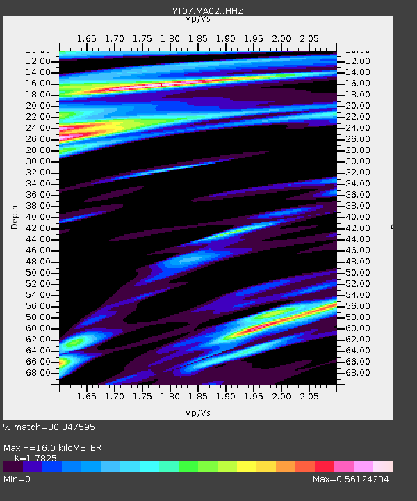
| Estimated Moho Depth: |
16.0 km |
| Estimated Crust Vp/Vs: |
1.78 |
| Assumed Crust Vp: |
5.77 km/s |
| Estimated Crust Vs: |
3.237 km/s |
| Estimated Crust Poisson's Ratio: |
0.27 |
|
| Radial Match: |
80.347595 % |
| Radial Bump: |
343 |
| Transverse Match: |
71.42954 % |
| Transverse Bump: |
370 |
| SOD ConfigId: |
11737051 |
| Insert Time: |
2019-04-25 12:22:12.526 +0000 |
| GWidth: |
2.5 |
| Max Bumps: |
400 |
| Tol: |
0.001 |
|

Signal To Noise
| Channel | StoN | STA | LTA |
| YT:MA02: :HHZ:20160912T07:00:11.070005Z | 2.0691953 | 2.6605997E-7 | 1.2858138E-7 |
| YT:MA02: :HHN:20160912T07:00:11.070005Z | 1.1345344 | 1.5071844E-7 | 1.3284607E-7 |
| YT:MA02: :HHE:20160912T07:00:11.070005Z | 0.82986635 | 7.6434425E-8 | 9.21045E-8 |
| Arrivals |
| Ps | 2.3 SECOND |
| PpPs | 7.4 SECOND |
| PsPs/PpSs | 9.6 SECOND |


