You are here: Home > Network List > YT07 - POLENET Stations List
> Station MA10 Polenet mini-array MA10 > Earthquake Result Viewer
MA10 Polenet mini-array MA10 - Earthquake Result Viewer
| Earthquake location: |
Easter Island Region |
| Earthquake latitude/longitude: |
-28.8/-112.3 |
| Earthquake time(UTC): |
2016/09/12 (256) 06:51:53 GMT |
| Earthquake Depth: |
10 km |
| Earthquake Magnitude: |
5.8 mww |
| Earthquake Catalog/Contributor: |
NEIC PDE/us |
|
| Network: |
YT POLENET |
| Station: |
MA10 Polenet mini-array MA10 |
| Lat/Lon: |
78.60 S/109.00 W |
| Elevation: |
1658 m |
|
| Distance: |
50.0 deg |
| Az: |
179.142 deg |
| Baz: |
356.209 deg |
| Ray Param: |
0.06837257 |
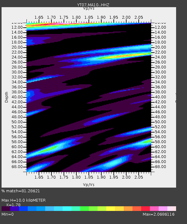
| Estimated Moho Depth: |
10.0 km |
| Estimated Crust Vp/Vs: |
1.78 |
| Assumed Crust Vp: |
5.872 km/s |
| Estimated Crust Vs: |
3.299 km/s |
| Estimated Crust Poisson's Ratio: |
0.27 |
|
| Radial Match: |
81.28621 % |
| Radial Bump: |
316 |
| Transverse Match: |
73.100494 % |
| Transverse Bump: |
331 |
| SOD ConfigId: |
11737051 |
| Insert Time: |
2019-04-25 12:22:17.231 +0000 |
| GWidth: |
2.5 |
| Max Bumps: |
400 |
| Tol: |
0.001 |
|

Signal To Noise
| Channel | StoN | STA | LTA |
| YT:MA10: :HHZ:20160912T07:00:16.468992Z | 2.966177 | 3.1814318E-7 | 1.0725697E-7 |
| YT:MA10: :HHN:20160912T07:00:16.468992Z | 2.0951867 | 1.7623276E-7 | 8.411316E-8 |
| YT:MA10: :HHE:20160912T07:00:16.468992Z | 1.4587811 | 9.512626E-8 | 6.520941E-8 |
| Arrivals |
| Ps | 1.4 SECOND |
| PpPs | 4.5 SECOND |
| PsPs/PpSs | 5.9 SECOND |


