You are here: Home > Network List > ZQ15 - Taku Glacier Stations List
> Station GUGU Taku Glacier, Alaska, USA > Earthquake Result Viewer
GUGU Taku Glacier, Alaska, USA - Earthquake Result Viewer
| Earthquake location: |
Easter Island Region |
| Earthquake latitude/longitude: |
-28.8/-112.3 |
| Earthquake time(UTC): |
2016/09/12 (256) 06:51:53 GMT |
| Earthquake Depth: |
10 km |
| Earthquake Magnitude: |
5.8 mww |
| Earthquake Catalog/Contributor: |
NEIC PDE/us |
|
| Network: |
ZQ Taku Glacier |
| Station: |
GUGU Taku Glacier, Alaska, USA |
| Lat/Lon: |
58.42 N/134.04 W |
| Elevation: |
139 m |
|
| Distance: |
88.7 deg |
| Az: |
348.761 deg |
| Baz: |
161.022 deg |
| Ray Param: |
0.042372808 |
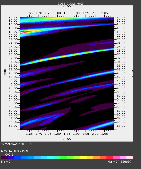
| Estimated Moho Depth: |
18.0 km |
| Estimated Crust Vp/Vs: |
1.60 |
| Assumed Crust Vp: |
6.566 km/s |
| Estimated Crust Vs: |
4.104 km/s |
| Estimated Crust Poisson's Ratio: |
0.18 |
|
| Radial Match: |
97.910515 % |
| Radial Bump: |
189 |
| Transverse Match: |
97.754585 % |
| Transverse Bump: |
183 |
| SOD ConfigId: |
11737051 |
| Insert Time: |
2019-04-25 12:22:29.601 +0000 |
| GWidth: |
2.5 |
| Max Bumps: |
400 |
| Tol: |
0.001 |
|

Signal To Noise
| Channel | StoN | STA | LTA |
| ZQ:GUGU: :HHZ:20160912T07:04:15.520017Z | 0.96257585 | 9.706168E-7 | 1.0083536E-6 |
| ZQ:GUGU: :HH1:20160912T07:04:15.520017Z | 0.16925798 | 5.002772E-7 | 2.9557086E-6 |
| ZQ:GUGU: :HH2:20160912T07:04:15.520017Z | 0.7851066 | 9.0838206E-5 | 1.1570174E-4 |
| Arrivals |
| Ps | 1.7 SECOND |
| PpPs | 7.0 SECOND |
| PsPs/PpSs | 8.6 SECOND |


